Indexed News on:

--the California "Mega-Park" Project

Tracking measurable success on preserving and connecting California's Parks & Wildlife Corridors

READ OUR EDITOR ON FACEBOOK: facebook.com/rex.frankel

Thursday, April 24, 2008

-----
Hitch in Anza-Borrego Power Lines Plan:
SDG&E needs permission to use park easement

By DAVE DOWNEY - Staff Writer Wednesday, April 16, 2008


http://www.nctimes.com/articles/2008/04/16/news/sandiego/301442b4d3ab270a8825742d0061e53c.txt

A San Diego Gas & Electric Co. official acknowledged Wednesday that the utility does not have permission to build its proposed power line within an existing electric right of way in Anza-Borrego Desert State Park.

Lynn Trexel, a company land adviser, said during a San Francisco hearing on the Sunrise Powerlink project that the company has yet to secure permission from the owners of the right of way, the U.S. Bureau of Land Management and the Imperial Irrigation District.The $1.5 billion, 150-mile high-voltage line has sparked protest from the environmental community and recreation enthusiasts because 22 miles of it would run through the popular state park in eastern San Diego County.

To avoid the need to obtain approval from state park officials to build a new line, the utility is trying to stay within the 100-foot-wide right of way by building taller, narrower towers.Of that 22-mile easement, the federal bureau controls access to 17 miles. Private entities, including the irrigation district, control other sections.

While being questioned Wednesday morning by attorney Carrie Downey of Coronado, Trexel acknowledged that Imperial Irrigation District has a competing proposal to build a line across the easement. Consequently, if the district's proposal and Sunrise Powerlink were approved, it is likely the two sets of wires would have to be hung from the same poles, she said.Trexel also acknowledged that the precise locations of easement boundaries are unclear in some places."There's been a history of land-surveying problems through the park," she said.

Under questioning by Harvey Payne, attorney for the Rancho Penasquitos Concerned Citizens, Trexel said SDG&E is seeking a 1.8-mile-long, 60-foot-wide easement from the city of San Diego to run the last leg of the line across the city-owned Los Penasquitos Canyon Preserve.Four miles east of there, within the community of Rancho Penasquitos, the wires will be buried in the ground ---- between Rancho Penasquitos Skate Park and the Park Village neighborhood.The hearing is one of many that have been conducted on the power line that was first proposed in December 2005. SDG&E wants to string 500- and 230-kilovolt wires between El Centro and Carmel Valley.

The California Public Utilities Commission is weighing the information being presented in the courtlike proceedings, and is expected to decide by August whether to license the project.Should the commission choose to reject the Sunrise Powerlink, SDG&E would have the option to appeal to the Federal Energy Regulatory Commission as early as October.

Tuesday, April 22, 2008


South Coast Wildlands Project Publishes Study and Maps of Crucial So-Cal Wildlife Migration Pinch-Points

(Click on map to enlarge)

Local wilderness corridors help species avoid isolation and extinction
By Mike Lee

SAN DIEGO UNION-TRIBUNE STAFF WRITER
March 20, 2008
http://www.signonsandiego.com/news/science/20080320-9999-1c20wild.html


To most passers-by, the vast valley that drains into Lake Henshaw offers little more than a scenic diversion on the way to Julian.

A view to the east from Cuyamaca shows the San Felipe Valley, a key wildlife pathway.But to wildlife scientists, it's one of the 15 critical wildlife corridors left in Southern California because it connects Palomar Mountain and Anza-Borrego Desert State Park.

Yesterday, after six years of work, South Coast Wildlands and about 20 partner groups released the most comprehensive assessment ever done of the region's habitat links and created what is likely to be a national model for conservation planning.

“This really is the leading edge,” said Paul Beier, a co-author of the linkages document and a conservation biologist at Northern Arizona University. “We have done a great job of making a scientifically rigorous assessment (of) what lands will best serve the needs of all native species.”

Using geographic information systems and more than 60 academic studies, the South Coast Missing Linkages Project offers detailed maps of the pathways that connect the large patches of open space owned mainly by state and federal agencies. The central goal is to enhance the movement of plants and animals between segments of more than 18 million acres of protected lands.

Mountain lions are of special concern because they require large areas to roam. Researchers used radio-collar tracking studies to identify the routes the lions already use and target those lands for special protections from development.

Three of the wildland linkages are in North County and three more – which have yet to be mapped in detail – cross the U.S.-Mexico border. The others stretch as far north as Bakersfield, where thin strands of habitat connect the Sierra Nevada mountains to the coastal range.

The maps are both heartening and sobering. They show that Southern California – one of the world's biodiversity hot spots – still has enough open space to support a wide range of native plants and animals. However, they also provide a reminder that if those linkages are broken, species will become isolated in smaller and smaller pockets of land.

“The exciting thing for me is that we ... can have 20 million people coexisting with intact wildlands. We haven't lost them yet,” Beier said.

Project proponents said the pathways will help agency officials and conservation leaders focus on the most important areas to safeguard. For instance, county officials are consulting the maps as they create two large-scale species conservation plans for north and east San Diego County.

The maps also can be used by the California Department of Transportation to locate places where improvements such as bridges and stream culverts could be designed to help the movement of wildlife. In addition, the maps support conservation leaders' long-standing vision of a “vegetated land bridge” over Interstate 15 near Fallbrook as a way to facilitate migrations for mountain lions and other species.
The pathways are taking on increasing significance as global warming alters habitats.

“As we protect these linkages from the valley floor to the mountains, there will be some escape routes for species” to find suitable microclimates at higher elevations, said David Van Cleve, a senior official with The Nature Conservancy in San Diego.

Creating a network of conservation areas is a departure from old-school ecology, which relied heavily on government agencies such as the National Park Service setting aside huge chunks of property. That's not viewed as practical these days.

“It's much more efficient both in terms of economics and in terms of biology to create linkages between the existing reserves,” Van Cleve said.

That approach relies on cooperative agreements with private property owners. Land conservancies, working with state and federal agencies, commonly provide financial incentives for landowners to limit development or improve the habitat on their parcels.

Thanks to the linkage blueprint, that can happen in a targeted and scientifically defensible way.
The new atlas has its roots in a statewide conference eight years ago that included some 200 land managers, scientists and conservationists. They identified 232 linkages statewide – a number that was too big to tackle all at once, said Kristeen Penrod, conservation director at South Coast Wildlands, a nonprofit group in Los Angeles that coordinated the pathways project.

She and her colleagues whittled the number down to 15 Southern California links that “are so important that if even one fails, the biological integrity of the entire region would be compromised.”
At first, the links were nothing more than arrows on a map. But over time, conservationists have refined the corridors down to a matter of meters.

Doing that took several steps, starting with the selection of 109 “indicator species,” including black-tailed jack rabbits, badgers, golden eagles and white alder.

Next, the scientists performed what they call a “landscape permeability analysis,” a computer technique that models the difficulty that the various species would have moving between large conserved areas. Factors include vegetation types, elevation, slope and road density.

The best potential route for each species was combined with the others to create the most favorable path for all modeled plants and animals.
After that, the scientists factored in the size of habitat parcels in the pathways and whether they are close enough to benefit the species.

Researchers then checked the models during field trips and documented migration barriers such as roads.
In addition to generating maps, South Coast Wildlands and its partners offered several recommendations for how to improve the habitat connections. They include: designing road culverts to maximize wildlife use, encouraging the use of native plants by residents, enforcing leash laws on public lands to reduce predation of wildlife, and stopping illegal use of off-road vehicles.

Now that the South Coast report is done – at the cost of about $700,000 – Penrod and others aim to export their analytical approach.

“Let's do the rest of California at the level of detail that actually provides an implementable vision,” she said.

-----
In Lassen County: Sierra's Dyer Mountain Ski Resort Developer Files Bankruptcy


http://yubanet.com/regional/Sierra-s-Dyer-Mountain-Files-Bankruptcy.php

By: Tom Mooers, Sierra Watch

Westwood, CA (Lassen County), April 2, 2008 - The biggest development proposal in the Sierra Nevada came to a halt when proponents Dyer Mountain Associates filed for bankruptcy in the Federal Bankruptcy Court in San Francisco March 27.

"Now that the threat of development is lifted, we look forward to working to secure permanent protection for Dyer Mountain and its incredible natural resources," said Steve Robinson of Mountain Meadows Conservancy.

Dyer Mountain Associates (DMA) began pursuing development on remote Dyer Mountain in Lassen County nearly ten years ago. With the promise of a new ski resort and local jobs, a version of the project was initially approved by a voter initiative in 2000. But the scope of the project ballooned into a vague plan for 4,000 new homes, three golf courses, and the ski resort on 7,000 acres of forest lands.

Developers had promised ski operations by November 2007, but the project mired in deepening legal and financial turmoil; DMA was subject to at least five lawsuits and two scathing court orders. In May 2007, for example, San Francisco Superior Court assigned a majority stake in DMA to a court appointed receiver, stating that DMA "...is in default of outstanding loans to creditors, payroll, rent and other financial obligations."

DMA continued to push its project through the planning process, and, in September of 2007, Lassen County gave its approval. A powerful coalition of local, regional, and international conservation groups filed suit. Mountain Meadows Conservancy, Sierra Watch, and Sierra Club petitioned Lassen County Superior Court to overturn the county's approval, contending the proposed development was not only irresponsible but also illegal.

In January 2008, creditors foreclosed on the property itself. With last week's bankruptcy filing, DMA seeks to suspend foreclosure and gain protection from remaining debt, including nearly $200,000 in back taxes owed to Lassen County.

"Folks in Lassen County and throughout California recognized that this was not the best way to plan the future of the Sierra Nevada," said Tom Mooers of Sierra Watch. "Now Dyer Mountain is becoming another example of how we can work together to defend our favorite Sierra places."

In the months ahead, conservationists will seek an opportunity to bring all parties to the table to seek a conservation resolution for Dyer Mountain. "Bankruptcy might put a halt to the DMA development proposal, but it doesn't achieve our goal," said Robinson. "We look forward to sitting down with county officials, creditors, conservation allies, and others to secure permanent protection of the property itself."

The Mountain Meadows Conservancy's mission is to conserve and enhance the natural beauty and environmental health of the Mountain Meadows watershed; protect its significant Mountain Maidu burial and cultural sites; and provide recreation and public access for generations to come. For more information, visit www.mtmeadows.org.

Sierra Watch defends the incomparable natural resources and unparalleled quality of life in the Sierra Nevada mountain range. For more information, call (530) 265-2849 or visit www.sierrawatch.org.

----------------------------

Dyer Mountain files bankruptcy

Apr 2, 2008

http://www.theunion.com/article/20080402/BREAKINGNEWS/406859781

The biggest development proposal in the Sierras has been put on hold after owners filed bankruptcy in a Federal Bankruptcy Court in San Francisco.

Dyer Mountain Associates filed for Chapter 11 bankruptcy protection on March 27 after pursuing development for ten years in a remote area of Lassen County known as Dyer Mountain.

Plans for the four season mountain resort included 4,000 homes, three golf courses and a ski resort on 7,000 acres of forest lands. The site is considered sacred by the Honey Lake Maidu.

In 2000, 62 percent of Lassen County voters approved re-zoning Dyer Mountain from timber production to a mountain resort.

In recent times the project has become mired in financial troubles with lawsuits stemming from defaulted loans and mismanaged funds.

Despite the problems, Lassen County approved the project in September 2007.

Mountain Meadows Conservancy, Sierra Watch and Sierra Club petitioned Lassen County Superior Court to overturn the county’s approval, contending the proposed development was illegal.

In January, creditors foreclosed on the property.

----------------

Ski resort files for bankruptcy

http://www.latimes.com/news/local/la-me-briefs3apr03,1,1268186.story

The owners of a Sierra Nevada mountainside who planned to build California's first major ski operation in three decades have filed for Chapter 11 bankruptcy protection, prompting environmentalists to renew calls to stop the controversial project.

A representative of Dyer Mountain Associates said the company still intends to pursue its proposal to turn nearly 7,000 acres abutting Walker Lake in Lassen County into a four-seasons resort with golf, mountain biking, boating and fishing and several thousand dwellings and hotel rooms.

Merle Meyers, the owners' attorney, said they filed for bankruptcy protection to avoid foreclosure on the property while seeking new loans or investors. "There is no intention of going out of business," he said. "It is still a great project and needs great capital."

Among the debts listed is nearly $200,000 in back taxes owed to Lassen County.

The project has been slowed by financial and legal troubles and infighting. County voters approved a more modest plan in 2000. But the plan grew, along with criticism from environmentalists and others who feared it would harm the area's quality of life, traffic, air, water and wildlife.

"We hope this [bankruptcy filing] takes the development proposal off the table," said Tom Mooers of Sierra Watch. "The project does not pencil out economically, environmentally or from any other standpoint."

-----------------

The developer’s website:

http://www.dyermtn.com/

and http://www.dyermountainusa.com/

WCB 5/2008

-----
5-22-2008: State Wildlife Board to Buy 5035 Acres of Critter Habitat at May Meeting

WILDLIFE CONSERVATION BOARD

May 22, 2008 10:00 A.M. 1/ State Capitol, Room 112 Sacramento, California 95814 http://www.wcb.ca.gov/

MAPS: https://nrm.dfg.ca.gov/FileHandler.ashx?DocumentID=14452

NORTH COAST:

6. Humboldt Bay Coastal Reserve, Expansions 2 and 3, $495,000.00 Humboldt County To consider the allocation for two grants to Friends of the Dunes for a cooperative project with State Coastal Conservancy and the State Department of Fish and Game to acquire fee title to two properties, totaling 53± acres located west of State Highway 255, southwest of Arcata, in Humboldt County.

20. Jacoby Creek Forest, Expansion 4, $509,000, Humboldt County
To consider the allocation for a grant to the City of Arcata for a cooperative project with the Humboldt Area Foundation and private donors to acquire fee title to 120± acres of land within the Jacoby Creek watershed, approximately seven miles southeast of the City of Arcata, in Humboldt County.


CENTRAL VALLEY:

*12. Canebrake Ecological Reserve, Canebrake Creek Unit $404,500, Expansion 3, Kern County To consider the acquisition of fee title to 196± acres as an addition to the Department of Fish and Game's Canebrake Ecological Reserve located near the community of Canebrake, northwest of State Highway 178, in eastern Kern County.

19. Rails to Trails, Modoc Line $420,000, Lassen and Modoc Counties
To consider the allocation for a grant to the Lassen Land and Trails Trust for a cooperative acquisition with the Department of Fish and Game, the Bureau of Land Management, and the Sierra Nevada Conservancy to acquire 86± miles of rail right-ofway covering 2,180± acres and running north from the town of Wendel, in Lassen County and ending south of Alturas, in Modoc County.

21. Mouth of Cottonwood Creek Wildlife Area $1,745,000, Balls Ferry Unit, Expansion 2, Shasta County
To consider the acquisition of fee title to 141± acres as an addition to the Department of Fish and Game's Mouth of Cottonwood Creek Wildlife Area located east of the community of Cottonwood, in Shasta County.

27. Millerton Preserve (Ecker Ranch) $3,015,000, Madera County
To consider the allocation for a grant to the California Rangeland Trust to acquire a conservation easement over 1,080± acres located 25 miles northeast of the City of Madera, near the community of Coarsegold, in Madera County.

28. Black Mountain Preserve, Expansion 3, $1,150,000, Fresno County
To consider the allocation for a grant to the Sierra Foothill Conservancy to acquire fee title to 358± acres located off of Tollhouse Road, in the Sierra Nevada Foothills, in Fresno County.


EASTERN SIERRA:

26. Wheeler Ridge Wildlife Area, Expansion 1, $840,000.00, Mono County
To consider the allocation for a grant to the Eastern Sierra Land Trust to acquire fee title to 33± acres located west of State Highway 395, south of Crowley Lake, in southern Mono County.


CENTRAL COAST:

32. Morro Bay Wildlife Area $810,000.00, San Luis Obispo County To consider the allocation for a grant to the Morro Coast Audubon Society; the acceptance of a Recovery Land Acquisition Grant from the U.S. Fish and Wildlife Service; and the authorization to enter into an Agreement to Subgrant the federal funds to the Morro Coast Audubon Society for a cooperative project with the State Coastal Conservancy and the Trust for Public Land to acquire fee title to approximately eight acres as an addition to the Audubon's existing Sweet Springs Preserve, located on the Morro Bay shoreline in the community of Los Osos, in San Luis Obispo County.


SOUTHERN CALIFORNIA:

*13. Coachella Valley Ecological Reserve (Edom Hill Unit) $5,000.00 Expansion 31, Riverside County
To consider the acceptance of a Habitat Conservation Planning Land Acquisition Grant from the U.S. Fish and Wildlife Service and the authorization to enter into an Agreement to Subgrant the federal funds to the Center for Natural Lands Management for a cooperative project with the Coachella Valley Mountains Conservancy to acquire fee title to 80± acres located southeast of the City of Desert Hot Springs, in Riverside County.

*14. San Jacinto Wildlife Area, Expansion 30, $400,000.00, Riverside County
To consider the acquisition of a conservation easement over 91± acres as an addition to the Department of Fish and Game's San Jacinto Wildlife Area located southwest of Mystic Lake, near Lakeview, in Riverside County. WITHDRAWN FROM AGENDA

*15. Santa Rosa Mountains Wildlife Area, Expansions 9 and 10, $280,000.00 Riverside County To consider the acquisition of fee title to two properties totaling 10± acres as additions to the Department of Fish and Game’s Santa Rosa Mountains Wildlife Area; the acceptance of a Recovery Land Acquisition Grant from the U.S. Fish and Wildlife Service; and the authorization to use the federal funds for the State’s purchase of the properties located west of Jefferson Street and south of Avenue 62, in the City of La Quinta, in Riverside County.

*16. Triple Creeks Conservation Area, Expansion 3, $5,000.00, Riverside County
To consider the acceptance of a Cooperative Agreement from the U.S. Fish and Wildlife Service and the authorization to enter into an Agreement to Subgrant the federal funds to the Western Riverside County Regional Conservation Authority to acquire fee title to 36± acres located west of State Highway 79, south of Scott Road in Murrieta, in Riverside County.

*17 Western Riverside County MSHCP, Expansion 3, $5,000.00, Riverside County To consider the acceptance of a Habitat Conservation Planning Land Acquisition Grant from the U.S. Fish and Wildlife Service and the authorization to enter into an Agreement to Subgrant the federal funds to the Western Riverside County Regional Conservation Authority to acquire fee title to 102± acres located approximately eight miles south of Hemet, in Riverside County.

*18 Ramona Grasslands, Expansion 3, $5,000.00, San Diego County
To consider the acceptance of a Habitat Conservation Planning Land Acquisition Grant from the U.S. Fish and Wildlife Service and the authorization to enter into an Agreement to Subgrant the federal funds to The Nature Conservancy for a cooperative project with the California Department of Water Resources and the County of San Diego to acquire fee title to 476± acres located west of the community of Ramona, in San Diego County.

35. El Sobrante $2,504,700.00, Riverside County
To consider the allocation for a grant to the Western Riverside County Regional Conservation Authority; the acceptance of a Habitat Conservation Planning Land Acquisition Grant from the U.S. Fish and Wildlife Service; and the authorization to enter into an Agreement to Subgrant the federal funds to the Western Riverside County Regional Conservation Authority to acquire fee title to 71± acres located within the Department of Fish and Game’s Natural Community Conservation Plan area, northeast of the City of Wildomar, south of Lake Elsinore, in Riverside County.

-----

The Bay is Under Assault

3/20/2008

The Bay once again is under assault from inappropriate development -- this time in Redwood City. The residents of Redwood City have a long history of protecting open space and the Bay shoreline. Bair Island, 3,000 acres of former salt ponds that is now being restored to healthy wetland habitat by the US Fish and Wildlife Service, was saved as open space by a vote of the public in 1982.


The OSV measure would
require public approval
prior to any development on
Redwood City open spaces,
parks and baylands


To stop future threats on the Bay and other open space lands in Redwood City, Save The Bay is pleased to be a sponsor of the Open Space Vote Coalition.

The Open Space Vote Coalition is a new partnership of local environmental and Redwood City neighborhood groups, including Friends of Redwood City and Sequoia Audubon Society. The coalition is proposing a Redwood City charter amendment that would require a public vote to approve any development on Redwood City open space, parks and baylands.

Approval of the "Open Space Vote" measure ensures that every Redwood City voter will get to weigh-in on Minnesota-based agribusiness giant Cargill̢۪s plan to develop its 1,433-acre salt pond site in Redwood City.

Visit www.saveSFbay.org/redwoodcity for more information.

Any development on these former Bay wetlands -- an area larger than San Francisco's Golden Gate Park -- would be the largest Bay fill project since Save The Bay was founded and would destroy forever any opportunity to restore these baylands to natural and vital wetland habitat.

To get involved in this effort, including help gathering signatures in Redwood City, please contact:

Stephen Knight at 510-452-9261x 112 or sknight@saveSFbay.org

-----
Chino Hills Defenders File Suit Over Road Through Park


3/19/2008

http://hillsforeveryone.org

Hills For Everyone partnered last week with Defenders of Wildlife, the Planning and Conservation League, and Friends of Harbors, Beaches, and Parks to challenge approval of a secondary access road to the Robert Diemer Water Filtration Plant (operated by MWD) that will cut through Chino Hills State Park in north Orange County. The organizations joined together in a suit that was filed in Orange County Superior Court on Thursday, March 13th.

The proposed road will climb a 45-degree slope through oak and walnut woodlands that are protected by a Habitat Conservation Plan (HCP) signed in 1994. These woodlands lie within the viewshed of Chino Hills State Park. Given the steep topography in the area, the road will require extensive engineering, including cut and fill slopes of up to 30 feet that are secured with a mechanically stabilized earth retaining wall system. Since the road is to be built over a mile into the mouth of Telegraph Canyon, the formal Orange County entrance to the State Park, the ambiance of the Park will be permanently damaged there. Park users will have to share this quiet canyon with truck traffic traversing a steep hill.

The California Department of Parks and Recreation is also named a party to the lawsuit because it will receive more than $1.7 million in compensation for its support of this Project. The Department has stated that it plans to use the money to finish, furnish and permanently endow a staff position for an Interpretive Center to be built nearby.

Many State Parks face threats to their integrity because agencies look at parks as placeholders for urban infrastructure. In our Park alone we have fought off eight roads over three decades. At this point we are extremely disheartened that in supporting MWD's massive road, State Parks has decided that interpreting the Park is more important than protecting it. As park rangers try to teach visitors about nature, how can they explain that their agency supported the destruction of oak and walnut woodlands and important wildlife habitat-all for a single staff person and some furniture?"
-----
143 Acres of Pristine Santa Barbara County Coastal Dunes Conserved


3/17/2008

http://LCSLO.org

The Land Conservancy of San Luis Obispo County is overwhelmingly excited to announce the permanent conservation of 143 acres of prime coastal dunes just north of Point Sal. The Dunes Collaborative has found the Point Sal and Paradise Beach area to be one of the highest priorities for land conservation initiatives in the entire Guadalupe-Nipomo Dunes Complex. After more than a year of work, the transaction was successfully completed just in time to celebrate the preservation of more “green” this St. Patrick’s Day.

The property includes roughly a ½-mile stretch of the white sands of Paradise Beach and several tidepool areas tucked into small, protected coves. According to the Point Sal Reserve Management Area Plan prepared by the firm of Storrer & Semonsen (c. 1990), other natural resources include thriving coastal dune and bluff scrub habitat, freshwater seeps, a marine mammal haul-out area, and several populations of endangered Surf Thistle (Cirsium rothophilum). The upland area of the property is described as a critical wildlife area that contains important habitat for mountain lion, bobcat, coyote, and deer.

“This is one of the most pristine and beautiful beaches I have ever been to in my life. We are thrilled to have the opportunity to protect it forever.” - Bob Hill, Conservation Director

This spectacular site provides stunning 360-degree views of ocean and dunes, and is an unspoiled example of what our native coastline looked like long ago. This area also held a special appeal to Don and Irene Gragnani who experienced its magic for many years but sold it for the purpose of continued conservation. The Gragnani’s regularly visited the property for picnic lunches and camping expeditions, and they are pleased to know that it will be maintained as a protected natural area for others to enjoy as well.

Project partners included the State Coastal Conservancy, the Central Coast Regional Water Quality Control Board, National Fish and Wildlife Foundation, The Dunes Collaborative, The Nature Conservancy, and Santa Barbara County Parks. The purchase was approved by The State Coastal Conservancy Board in January and The Central Coast Regional Water Quality Board in February. Santa Barbara County Parks has expressed a strong interest in the long-term ownership and management of the property as they are already adjacent landowners.

The project is representative of The Land Conservancy’s ongoing commitment to protecting, restoring, and stewarding the unique and fragile ecosystem that makes up the world class Guadalupe-Nipomo Dunes through collaborative efforts with our many partners.

Registration for our Tenth Annual Conference is now open!

Nature Within Reach is what makes the Bay Area so special, yet it also presents us with some of our most pressing challenges as the region continues to grow. Local agriculture, urban parks, water and air quality, climate change, wildlife habitat - there are many important reasons that the Bay Area needs to maintain and increase its system of natural areas.

This year's Conference will feature noted speakers and presentations that will showcase regional planning efforts and demonstrate creative approaches to ensuring both cultural and biological diversity. Learn about transformational leadership involving individuals and groups coming together to change the economic, environmental, and social landscapes of their regions by rediscovering their communities' visions and developing new paths and unconventional alliances to reach their goals.

The Conference will be held on Wednesday, May 21st from 8:00a-4:30p at the Golden Gate Club in San Francisco's Presidio. As last year, there will be no conference registration at the door, so you must pre-register. Early registration ends on April 11th, and regular registration ends on May 2nd. The event has reached capacity for the last several years, so make sure to reserve your spot early.

Agenda highlights include speakers on Agriculture, Environmental Education, Biodiversity and Collaboration.

Two Exhibit Halls will be filled with displays about agencies, organizations, professionals and businesses that protect and manage the region's diverse parks and open spaces.Please see our website for more details.

We will also see images from Christopher Beaver's book After the Storm: Bob Walker and the East Bay Regional Park District.

For more detailed information and to register for the conference, click on the link below:


To become an Exhibitor or Sponsor, please use the link above or contact Elizabeth Adam at 415.235.2756 or conference@openspacecouncil.org.

We look forward to seeing you there!

Elizabeth

Elizabeth Adam,Director of Marketing and Communications
Bay Area Open Space Council510.834.8399 (office)415.235.2756 (mobile)www.openspacecouncil.org
M, T, Th 8:30a-5:30p
-----
Feds (Actually!) Give Almost $18 million to Save Wildlife Habitat in California for 2008


3/20/2008

http://www.doi.gov/news/08_News_Releases/080320.html


http://www.fws.gov/pdfs/Sect6FY2008AwardSummariesFINAL.pdf


California's total is $17,945,231

Authorized by Section 6 of the Endangered Species Act, the grants enable States to work with private landowners, conservation groups and other agencies to initiate conservation planning efforts and acquire and protect habitat to support the conservation of threatened and endangered species.


San Diego County:

$4.9 million to buy 230 acres in the East Elliot and Otay Mesa areas in San Diego County

$600,000 to buy 1080 acres in San Diego County's Jacumba area for the Quino's checkerspot butterfly

$1 million to buy 1020 acres in San Diego County's La Posta area


AND THE REST OF THE STATE:

$6 million to the East Contra Costa County to save 2000 acres of red legged frog habitat

$1.7 million to save 64 acres in Santa Cruz County's Willow Canyon

$671,000 to Mendocino County Mackerricher State Park to buy 64 acres of coastal dunes

$490,000 to save Placer County's Big Gun property, 21 acres of red-legged frog habitat

$466,000 to buy 2869 acres in Riverside County's Santa Rosa Mountains
-----
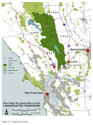
A Look at Some of the Groups Working to Save the 20 Mile Wide By 100 Miles Long Blueridge-Berryessa Preserve Between the North San Francisco Bay Area and Sacramento


http://www.tuleyome.org/projects/campaigns/blueridge/index.html

http://bioregion.ucdavis.edu/what/brbna.html

The Blue Ridge Berryessa Natural Area (BRBNA) focuses on Blue Ridge and the lands to the east and west of the ridge, down to the Capay Valley on the east side and over towards Coyote, Long, and Pope valleys on the west. It stretches from Monticello Dam in the south to the area north of Highway 20 between Williams and Clear Lake. Straddling the ancient contact between the rocks of the continental and Pacific tectonic plates, the area's diverse geology supports a unique assemblage of ecological communities including serpentine chaparral, grasslands, oak woodlands, and extensive riparian and cliff habitats.

Wildlife abounds. The area is sufficiently large and remote to support tule elk, bald and golden eagles, mountain lions and bears, as well as diverse songbirds, raptors, amphibians, reptiles and fish. The serpentine soils of the region host a large number of indigenous and rare plants, while Cache and Putah Creeks, along with their tributaries and the region's lakes, provide abundant fisheries.

---------------------------

http://www.berryessatrails.org/

http://www.berryessatrails.org/lakedistrict.htm

The Napa County Lake District is part of the larger Blue Ridge Berryessa Natural Area (BRBNA), a natural area of some 750,000 acres spead over portions of five counties, half of which is public land. The BRBNA is the subject of a voluntary conservation partnership (the BRBNA CP) in which BT&C is a partner, dedicated to conserving the natural, recreational and agricultural lands within the BRBNA. Trails planned in the Lake District form the core of the regional trail system being planned in the BRBNA, starting with the Bureau of Reclamation's proposal for a 150 mile Lake Berryessa Shoreline Trail.

Most of the 80,000 acres of land in the Lake District is held by two federal bureaus of the Dept. of the Interior - the Bureau of Land Management (BLM) and the Bureau of Reclamation (BOR) plus a state agency, the California Dept. of Fish and Game (DFG). The fourth major public landholder is the UC Davis Nature Reserve System (NRS). Despite the extensive public land holdings, there are few formal trails in the Lake District, and finding access to the public land can be difficult.


Major Public Land Parcels

1. Quail Ridge (NRS) - 2,000 acres, southeast of the Lake, scheduled hikes
2. Lake Berryessa Recreation Area (BOR) -19,000 acre lake plus 9,000 acres of land around the shoreline, Smittle Creek Trail and the North End Trail
3. Cedar Roughs (BLM) - 6,000 acres in the hills to the west of the Lake, no formal trails, proposed Wilderness area
4. Berryessa Peak Blue Ridge (BLM) - 9,000 acres (includes substantial portion in Yolo County) on Blue Ridge to the east of the Lake, surrounded by private land there is currently no public access
5. Knoxville Wildlife Area (DFG) - 20,000 acres, no formal trails but many old ranch roads. Includes the new 12,575 acres of public land acquired in December 2005
6. Blue Ridge (BLM) - 700 acres, while a small parcel in Napa County, this land is contiguous with the Cache Creek Natural Area which is 70,000 acres of land primarily in Lake and Yolo Counties. There is no trail in Napa County but there is an 8 mile trail north along Blue Ridge to the north of Napa
7. Knoxville Recreation Area (BLM) - 17,000 acres (includes substantial portion in Lake County) west of the Knoxville Wildlife Area, a portion of this large parcel includes OHV trails and a campground
8. McLaughlin (NRS) - 7,000 acres (includes substantial portion in Lake County), occasional guided hikes

-------------------------------

http://www.nature.org/wherewework/northamerica/states/california/press/napa121605.html

Conservation partners protect 12,575-acre ranch in Napa County
Public-private partnership takes critical step toward preserving open space and completing wildlife-compatible recreational area in popular Napa region

Sacramento, Calif.—December 15, 2005—The Wildlife Conservation Board, in partnership with the Blue-Ridge Berryessa Natural Area Conservation Partnership, the Department of Fish and Game, the California Coastal Conservancy, The Land Trust of Napa County and The Nature Conservancy, today announced the acquisition and protection of the 12,575-acre Napa Ranch, an important milestone in protecting the region’s natural areas and providing wildlife-compatible recreational opportunities. The property, which will become part of the California Department of Fish and Game’s Knoxville Wildlife Area, includes one of the last unprotected segments of the 70,000-acre Eticuera Creek watershed, which supports a wide variety of threatened plants and animals.

“What the Point Reyes National Seashore is to San Francisco, or the Santa Monica Mountains National Recreation Area is to Los Angeles, the Blue-Ridge Berryessa Natural Area can be for our region,” said Ray Krauss of the Blue-Ridge Berryessa Natural Area Conservation Partnership, a coalition of private landowners and public land managers dedicated to conserving 750,000 acres in portions of Napa, Yolo, Solano, Colusa and Lake counties. “More than 10 million people live within a three hour drive of the BRBNA, and that population is expected to increase 33 percent by 2020. The protection of Napa Ranch is a big step in our effort to protect the region’s natural treasures and its way of life before it’s too late.”

The acquisition of Napa Ranch contributes 12,575 acres to the Knoxville Wildlife Area and a network of open space that spans the Cache Creek Wildlife Area, the Cache Creek Natural Area, the Knoxville Wildlife Area, the McLaughlin Reserve, the Cedar Roughs Wildlife Area and the Lake Berryessa public lands. Protection of the property preserves an important wildlife corridor serving a variety of wide-ranging animals, including mountain lion, bear and bald and golden eagle. Napa Ranch also contains one of the last unprotected segments of the Eticuera Creek watershed, which spans 70,000 acres of oak woodlands and serpentine chaparral — two highly threatened vegetation types in California of which only a small percentage remains. While only four percent of oak woodlands are protected in California, they are known to support more than 80 species of migratory and resident birds and more than 330 species of amphibians.

Napa Ranch was purchased by the Wildlife Conservation Board in cooperation with the Blue-Ridge Berryessa Natural Area Conservation Partnership, the California Coastal Conservancy, The Land Trust of Napa County and The Nature Conservancy for $12,500,000 using public and private funds. The Wildlife Conservation Board allocated $7,200,000 for the purchase and received a $2,300,000 Land and Water Conservation Fund grant from the National Park Service, a $1,500,000 grant from the State Coastal Conservancy, a $1,000,000 grant from Resource Legacy Fund Foundation’s Preserving Wild California program secured by the Napa Land Trust and a $500,000 grant from The Nature Conservancy.
LA meetuphikes.org

E-Mail the editor:

rexfrankel at yahoo.com

Blog Archive

Quick-Search of Subjects on the Site