Indexed News on:

--the California "Mega-Park" Project

Tracking measurable success on preserving and connecting California's Parks & Wildlife Corridors

READ OUR EDITOR ON FACEBOOK: facebook.com/rex.frankel

Thursday, October 18, 2007

Parks Agency to Buy 850 Acres that Stretches from the Crest of the Santa Monica Mountains to the Ocean at October 22, 2007 Meeting


Upper Corral Canyon Has Been on the Conservancy's Wish-List for a Long Time

http://smmc.ca.gov

Staff Recommendation: That the Santa Monica Mountains Conservancy adopt the attached resolution authorizing a grant of Proposition 84 funds in the amount of $4,015,000 to the Mountains Recreation and Conservation Authority for the acquisition of approximately 850 acres.

The property owner is a willing seller, and the Trust for Public Land has already negotiated a
purchase agreement. The appraisal has been approved by DGS. Additional funds for the
acquisition will be contributed by the State Coastal Conservancy, the Wildlife Conservation
Board, California State Parks, the Santa Monica Bay Restoration Commission, and the Los
Angeles County Regional Park and Open Space District. The MRCA requests that the term of
agreement begin October 22, 2007 and end no earlier than December 31, 2008.
Corral Canyon is the last remaining coastal canyon in the Los Angeles County portion of the
Santa Monica Mountains with a contiguous band of natural land from the ocean to the crest of the range. This unique canyon encompasses Malibu Creek State Park in its headwaters and
Dan Blocker State Beach at the mouth of Corral Creek. The upper watershed supports dense
chaparral vegetation that transitions into a less woody coastal sage scrub closer to the ocean.
A mixed riparian woodland with white alders, California sycamores, willows, and coastal live
oak thrive around Corral Creek. Near Pacific Coast Highway, the creek broadens into a
gravelly flood plain with an open scattered mix of willow, mulefat and other riparian species
that adapt well to flooding. The last hundred feet of the creek upstream from the Pacific Coast
Highway bridge is subjected to tidal influence. The result is a small salt marsh characterized
by low growing salt tolerant plants. Many sections of Corral Creek retain year-round surface
water. A broad coastal bench located just east of the Corral Canyon trailhead supports some
of the best remaining coastal bluff native grasslands in the Santa Monica Mountains.

Tuesday, October 16, 2007

WCB 11/2007

------------
11-15-2007: 8403 acres of California Wildlife Habitat to be saved at Meeting of the State Wildlife Conservation Board

MINUTES OF MEETING:


998 acres to be Purchased in Riverside County:

Wilson Creek expansion 6, 18.9 acres, located south of Hemet

Wilson Creek expansion 7, 352 acres

Western Riverside expansions 1 & 2, 172+ acres located along the Interstate 15 corridor

Santa Rosa Mountains expansion 8, 100 acres located in the Santa Rosa Mountains area south of the city of La Quinta, in Riverside County

Santa Rosa Plateau, Tenaja Corridor, 30 acres

Triple Creeks expansion 2, 6 acres north of the city of Murrieta

Edom Hill expansion 30, a 320 acre addition to Coachella Valley Ecological Reserve located southeast of the city of Desert Hot Springs,

Monterey County:

Elkhorn Slough expansion 16, 7.47 acres of land as an addition to the Elkhorn Slough Ecological Reserve, located in the town of Castroville in Monterey County,


San Diego County:

Iron Mountain/Monte Vista: acquisition of a 4,056+ acre property referred to as Monte Vista Ranch. The property is located south of the community of Ramona in central San Diego County

Los Angeles County:

Bluebird Preserve expansion 1,  262+ acres in the city of Glendora,


Sierra Nevadas:

Pine Hill/Salmon Falls expansion 5: acquisition of 80+ acres of vacant land in El Dorado County

Truckee River Wildlife Area, Gray Creek Canyon Unit in Nevada County:
donation of three parcels of land, totaling 1,343+ acres, by the Truckee Donner Land Trust to the Department of Fish and Game;


North San Francisco Bay area:
Napa-Sonoma Marshes Wildlife Area, Tolay Creek Unit expansion 5: fee acquisition of 1,657+ acres of land located west of Highway 121, south of the city of Sonoma, in Sonoma County;

Sunday, October 14, 2007

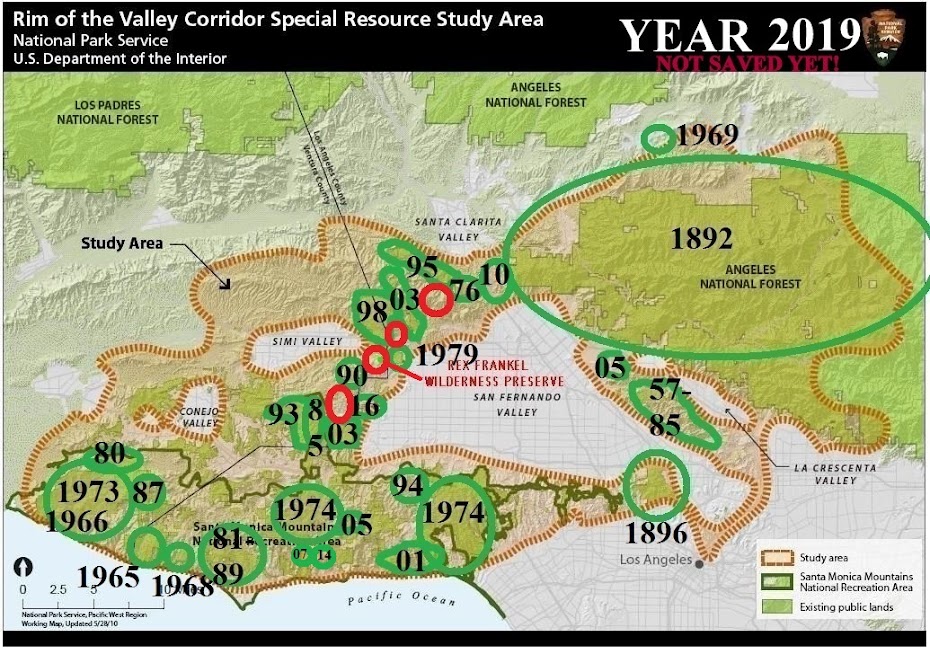
Rocketdyne/Simi Hills to be Parkland

Deal is Reached to Save 2400 Acre Parcel That is Vital Link in Parks Corridor Connecting Santa Monica Mountains and Open Spaces in North L.A. and Ventura Counties


(saved parcel is in red outline. Click on map to enlarge)


Boeing to clean Valley site
Contaminated laboratory will become a park under agreement with state leaders.

Staff Writer, L.A. Daily News/Daily Breeze

SACRAMENTO - In a landmark deal cheered by local environmental activists, Boeing Co. has agreed to donate its contaminated Santa Susana Field Laboratory site in the San Fernando Valley to the state of California for use as open space after cleaning it up to state standards.

The deal, negotiated by Gov. Arnold Schwarzenegger's administration, also calls for the company to contribute $22.5 million over 30 years to an endowment fund to maintain the property as parkland.

Neighbors and environmental activists previously had been worried that the company would inadequately clean the property and then sell it to a residential developer, creating homes on contaminated land and stirring up toxic dust with construction.

But under pressure from legislation authored by Sen. Sheila Kuehl, D-Los Angeles, that would force a very strict standard of cleanup, the company decided to donate the land in exchange for a standard that is seen as slightly less restrictive, but still tougher than the current cleanup effort.

"I think Boeing, frankly, saw the writing on the wall," Kuehl said.

Kuehl's bill, which the governor also said he intends to sign as part of the package, prohibits the sale or transfer of the 2,850-acre property until it is cleaned up to state standards, which are seen as much stricter than the current cleanup under federal regulations.

Now that Boeing has agreed to turn over its property for open space, Kuehl said she will introduce new legislation that will allow the company and the state to negotiate a new standard that will supersede the one in her bill.

Boeing owns about 2,400 acres of the property, and NASA owns the rest. The company said it will work with NASA to acquire its land and also clean it up.

Soil and water contamination from the property, used in the 1940s for rocket tests and nuclear-energy research, has long been seen as a cause of health problems in the community, including higher-than-usual rates of cancer. The property is in the hills above Simi Valley and Chatsworth.

Schwarzenegger said the new deal should help protect the community.

"I am pleased to announce this historic agreement will benefit the environment, nearby residents in Ventura County and the people of California," Schwarzenegger said in a written statement. "I would like to applaud Senator Kuehl for her leadership on this issue and commend the Boeing Company for working with officials to come up with this solution that will protect the health of residents in adjacent communities."

Kuehl has been working for more than a decade to strengthen cleanup efforts at the facility and has introduced a handful of bills over the years that failed, in part due to heavy lobbying by Boeing.

Kuehl credited freshman Assemblywoman Julia Brownley, D-Santa Monica, for helping to "strong-arm" colleagues in the Assembly, where Kuehl has in the past had trouble getting legislation through.

In addition, support from two Republicans whose districts border the property, Assemblyman Cameron Smyth, R-Santa Clarita, and Audra Strickland, R-Camarillo, were seen as helping the bill pass and gain support from Schwarzenegger.

Boeing officials said the company was trying to be a good corporate citizen in agreeing to the deal. Spokeswoman Blythe Jameson estimated it will take at least 10 years to clean up the property.

Friday, October 12, 2007

Clover Valley Oak-Destruction Project Brings Out Thousands of Opponents to Sign Petitions Putting Development Plan on the Ballot

Developer's campaign to get citizens to rescind their signatures fails.

9/28/2007 ROCKLIN, CA. -- It's official. Earlier this week, the Rocklin City Clerk and the Placer County Elections Division certified that the Save Clover Valley Coalition submitted enough valid signatures to qualify a referendum to overturn a recent decision by the Rocklin City Council to amend the city's general plan and move forward with the controversial Clover Valley development project.

(Editor's note: The Clover Valley development would construct 558 homes in a 622 acre canyon that lies between the gated housing tracts of Rocklin and the rural community of Loomis. The developer promises to leave about half of the site as open space but will have to remove over 7000 oak trees and construct roads dividing the remaining open space into islands in order to get cars to the home sites. To see the developer's misleading aerial photo of the completed project, in which the entire site appears to be preserved, go to http://www.clovervalleypartners.com/open_space.php.

Note that the aerial photo caption says "after replanted trees are grown". Below is the actual map of "open space", with homes and roads in red shading, showing how the preserved land would be islands in a a sea of concrete. Click on it to enlarge.)


Rocklin City Clerk Barbara Ivanovich will submit the certification to the City Council for review at its regular meeting Oct. 9. At that time, the Council can either rescind its earlier decision, or it can put the referendum to the Rocklin voters to decide.

“We certainly hope that the City Council finally sees that the voters of Rocklin want Clover Valley protected and chooses to rescind their decision rather than force this on the ballot,” said Elaine O’Deagan a spokesperson for the Save Clover Valley Coalition.

To qualify the referendum, the Save Clover Valley Coalition needed 2,706 signatures of registered Rocklin Voters (10 percent of the registered voters), and easily surpassed that figure, turning in nearly 5,000 signatures. The signatures were turned in some 10 days prior to the 30-day deadline, despite a heavily financed blocking campaign on the part of the developers, Clover Valley Partners. A recent poll taken by the Clover Valley Foundation showed that voters almost 3 to 1 would vote in favor of a referendum to Save Clover Valley and overturn the General Plan Amendment allowing its development.

“No one can question now that the citizens of Rocklin have proved beyond a shadow of a doubt that saving Clover Valley is important to them,” said Save Clover Valley committee officer Linda Hall, who submitted the 4,843 signatures last week. “People clearly want this amazing valley saved. They don't want more traffic on our streets. They don't want thousands of Oak trees cut down and they don't want to see homes built on and around ancient Native American burial grounds and other historically significant sites.”

Hall called on the City Council to support Rocklin voters on this issue. “As elected officials -- put in office to represent the will of the people -- I think the City Council members have a duty to take another look at this issue and do the right thing by the people of Rocklin and rescind their decision and save this valley,” she said.

Clover Valley Photo Gallery

The Referendum Will Give the Voters of Rocklin a Say About the Fate of Clover Valley - Learn More

For more information about the Save Clover Valley Coalition, visit http://saveclovervalley.org or http://savingclovervalley.org.

----------------------------------------
The Sierra Club Reports:

http://motherlode.sierraclub.org/placer/index.html

Because the owners/partnership/developers have indicated a willingness to sell, we have been working with state agencies, land trusts, conservancies, and any other entities that may be able to help purchase the valley. As environmentalists, the negotiations and talks are way beyond our areas of expertise, but we believe the preliminary meetings with professionals are proceeding cautiously, but positively.

-------------------------------

Thousands of Years of Archeological Resources Will Be Wiped Out...

State Historic Preservation Officer, Appointed by the Governor of California Tells City of Rocklin the Environmental Impact Report Does NOT Comply with CEQA. Here are some Quotes from the SHPO, the Authority for the Historical and Cultural Resources for the State of California - The Authority as it pertains to the Historical and Cultural Resources for the State of California:

"The FEIR does not meet CEQA’s fundamental basic disclosure requirement, the law’s intent to provide information for meaningful public comment."

"The RDEIR and the FEIR have not complied with the requirement of CEQA to provide the information required by the public including this office under CEQA to offer meaningful comment."

"The withholding of salient information renders the CEQA process inadequate."

"OHP has had an opportunity to visit Clover Valley it has become very apparent that the Determination of Eligibility and Effect on Cultural Resources within the Clover Valley Lakes Project Area, Peak (2002) is less than adequate because of the resources that were discovered during the site visit. Therefore, the basis of discussion, the resource identification pursuant to the section 106 process, requires reevaluation; there is a need for a new survey."

"My office has the following serious concerns: project mitigation is a non-existent Historic Properties Management Plan (HPMP); the Cultural Resources survey is inadequate; and implementing any action prior to conclusion of Section 106 may threaten a 404 permit."

View Comment Letter for FEIR sent by State Historic Preservation Officer, Milford Donaldson, Appointed by the Governor of the State of California, to the City of Rocklin Concerning the FEIR.

--------------------------

From : http://saveclovervalley.org/

Clover Valley has remained an undiscovered place.

Beaver dams create a succession of waterfalls along the length of Clover Valley Creek. Deer and newborn fawn graze undisturbed on the tall grasses. Birds are thick in the trees. The steep hillsides are blanketed with ancient oaks. Most importantly, from the valley floor the eye finds no reference to the present day. Enter Clover Valley and you enter a time machine.

It was recently discovered that a 1998 archaeological study of the valley found some 34 Native American cultural sites dating back to 5000 B.C. Clover Valley was a hub of regional Native American activity. Individual home sites, village lodge sites, cooking areas, ceremonial art and even a "ballfield" are there as they were left. The complete historic record is intact, wholly undisturbed in the top meter of earth, as it was created during 7,000 years of continuous Native American occupation.

So significant is the site that it qualifies as a historic district and for registry with the National Registry of Historic Places. However, at this time no trespassing is permitted and it's strictly enforced.
CHINO HILLS NEWS FROM http://hillsforeveryone.org

October 4, 2007

Greetings!

There is a new organization in town working to preserve the quality of life for the residents. This newsletter covers upcoming local events with Diamond Bar CARD.

Diamond Bar CARD (Citizens Advocating Responsible Development) will be hosting a Candidate's Forum on Tuesday October 9th at 7:30 PM. The event will be held at the United Church of Christ at 2335 S. Diamond Bar Blvd. This is located just north of Pathfinder on the west side of the street. All five city council candidates (three challengers and two incumbents) have been invited. To date three candidates have agreed to come. Two council seats are up for election on November 6th.

Following the questions, residents will have a chance to speak individually with the candidates and learn the latest on the Shell-Aera project.

The hardy souls of Diamond Bar CARD continue to circulate a petition and gather signatures to oppose both the development of the hills along the 57 freeway as well as the relocation of the Diamond Bar Golf Course. They could use all the help they can get with more signature gatherers. These petitions are available to be downloaded online at: www.DiamondBarCARD.com or you can pick up both petitions and new bumper stickers at the forum.

One measure of their rising presence is the fact that Shell-Aera's Public Relations consultant, Laer Pearce, has been attacking the accuracy of their website.

SHELL-AERA PROJECT UPDATE:

Supposedly the Draft Environmental Impact Report (DEIR) will be released this winter. Once released, the public, agencies and jurisdictions will have a 45-60 day time frame in which to comment on the DEIR.

These comments will then be responded to in a Final EIR. The public will then have another chance to comment on that document. Then the hearings begin - first before the Diamond Bar Planning Commission and next before the Diamond Bar City Council.

THE ROWLAND HEIGHTS MONKEY-WRENCH:

Residents of the unincorporated community of Rowland Heights, just west of Diamond Bar, are taking steps toward city hood - just as Diamond Bar residents did in the late 1980s.

Because Shell-Aera's land west of the 57 freeway is within the Planning Area and existing Community Standards District of Rowland Heights, this drive toward city hood could doom the City of Diamond Bar's effort to annex this portion of Shell-Aera's holdings.

Organizers of city hood are receiving the pro bono (free) services from an attorney firm, an engineering firm and a human resources firm. These are all indications of the confidence of these businesses that the city hood effort will be successful.

The city hood effort by residents of Rowland Heights can be viewed at www.RowlandHeightscity.org.

-------------
Palm Springs-Chino Canyon Battle News


NO on C Campaign Update October 5, 2007


Dear Supporters:

Only one month to go on our campaign to protect Chino Canyon by overturning an extension to the outdated and flawed development agreement with Shadowrock LLC.

The Shadowrock people are spending hundreds of thousands of dollars to undermine our efforts with the worn out tactic of the lie campaign. What else can they say? The truth is not on their side.

We stand by every statement we’ve made and have the documents to support them - including a recent report from the City Attorney that validates what we’re saying about the flaws and loopholes in the 1993 Development Agreement that are big enough to drive a bulldozer through. Go to saveourmountains.com to read this report.

Our job is simply to get the truth out. Here’s how you can help:

1. Donate to the cause – it’s very expensive to get our message in front of voters, especially competing against deep pocketed developers who are inundating voters with their messages

2. Forward this email on to all your friends and colleagues to help spread the word about the NO on C campaign

3. Put up a NO on C yard sign (they'll be ready on Monday for distribution)

4. Write a letter to the editor (mydesert.com) stating why you're voting NO on C

5. Volunteer – there’s much to do!
  • Host a house party! If you can get 8-10 people together at your house, give us a call at 832-6695. We'll be happy to come and speak about the Referendum and show a short film on the Chino Canyon that was screened at the Palm Springs International Festival of Short Films (for more information see 7. below.)
  • Yard sign assembly and delivery people needed! Call 832-6695 to arrange to help.
6. View VOICES of the CANYON a wonderful film about Chino Canyon that eloquently expresses why the Canyon is worthy of protection.
http://www.youtube.com/watch?v=COgTYQPW51c
This film was produced by Friends of Palm Springs Mountains and Juniper Tree Studios. Tell the world to watch this film!

7. Go to saveourmountains.com
a. to learn more about the campaign so you can share this information with others
b. download a NO on C window poster to hang in a visible place
c. to donate, volunteer and sign up for a yard sign

8. And MOST IMPORTANTLY.... V O T E!! NO on Measure C.

You can also email jono@saveourmountains.com or call 861-5365

Thursday, October 11, 2007

-----------
Showdown This Week Between Schwarzennegger's Dam(n) Bill and Democrats' Water Conservation Plans


October 8, 2007: This week, the California Legislature will decide the future of our rivers and the Sacramento-San Joaquin Delta. Will your voice be heard? Only if you email your State Senator TODAY!

https://secure2.convio.net/fotr/site/Advocacy?pagename=homepage&page=UserAction&id=139&JServSessionIdr009=zt6cacxou1.app14b

In an extraordinary session called by Governor Arnold Schwarzenegger, the California Legislature will vote as early as this week on two bills that provide funding for water resource projects in California.


The Bad Plan:

The Governor’s vision of building more river-destroying dams and diverting more freshwater from the already failing Sacramento-San Joaquin Delta is embodied in SBX2 3, introduced by Senator Cogdill. This misguided and devious bill places on the February 2008 statewide ballot a budget-busting $9 billion bond measure that will provide $5.6 billion to build three new, costly, and destructive dams in California (for more information about these dams, click here).

https://secure2.convio.net/fotr/site/Advocacy?pagename=homepage&page=SplashPage&id=139&AddInterest=1104&JServSessionIdr009=zt6cacxou1.app14b

The Schwarzenegger-Cogdill bill also allocates nearly $2 billion to increase pumping of freshwater from the Delta, which has already been decimated by freshwater diversions.


The Good Plan:

The President of the State Senate, Don Perata, has introduced an alternative vision for California rivers and the Delta. SBX2 2 would place on the February 2008 ballot a $6.8 billion bond measure that provides $2 billion for local integrated water planning efforts focusing on water use efficiency, recycling, and groundwater clean-up strategies to allow regions to become more self-sufficient in terms of water supply. The bill also provides $2.4 billion to improve Delta sustainability. Senator Perata’s bill specifically prohibits expenditures that would construct new Delta pumping or water transfer facilities. Another $1 billion is provided in the bond for the restoration of the Klamath, Sacramento, San Joaquin, Los Angeles, San Gabriel, Santa Ana, and other rivers in the state.

Email your State Senator TODAY urging “Nay” on SBX2 3 (Cogdill) and “Aye” on SBX2 2 (Perata), The State Senate could vote on these water bond bills as early as Wednesday, October 10, 2007. So write a letter TODAY! For more information, click here or contact Soren Jespersen (x204) or Steve Evans (x221) at (916) 442-3155, or via email at soren@friendsoftheriver.org or sevans@friendsoftheriver.org.

----------
North San Diego County's Margarita Peak is Saved!


In August of 2007, the Fallbrook Land Conservancy acquired the 1206-acre Margarita Peak property northwest of Fallbrook. This acquisition involved a partnership between the Department of Defense, the California Wildlife Conservation Board, the Trust for Public Land, and the Fallbrook Land Conservancy (FLC), and is part of the Marine Corps Camp Pendleton buffer and open space connectivity program. The purpose of this program is to use Department of Defense funds to purchase conservation easements on land near the marine base to ensure compatible uses of properties, and to maintain open-space corridors for wildlife movement. The funds from this grant will be used to (1) prepare a baseline document describing the geographic, geologic, and biologic properties of the 1206-acre Margarita Peak property, and (2) develop a stewardship plan that will satisfy the goals of the Camp Pendleton buffer zone program, preserve the biologic values of the land and allow for compatible passive use by the public. In preparing the baseline documentation and developing the stewardship plan, we hope to draw upon the mapping resources, when possible, of Camp Pendleton's office of environmental Security, the Fallbrook Public Utility District, and the Cleveland National Forest. Benefit to the Organization and the Local Community This is the major first step of a regional program involving the members of the South Coast Conservation Forum, including the Department of Defense, the California Wildlife Conservation Board, the Trust for Public Land, The Nature Conservancy, the Fallbrook Land Conservancy and others in what is anticipated to be a series of openspace purchases in the vicinity of Camp Pendleton and possibly other military bases in the area. As such, it is important to set standards for the stewardship of the land that will ensure compatible use, while protecting the biologic values of the land, and allowing for passive use by the public. These standards may then be used as a guide for future lands acquired in this and similar programs.

For more info, see http://www.sdlcc.org/flc/
or
http://sdcrn.org/about/fallbrook-land-cons.html

SDCRN is a service organization that supports 25 other conservation NGOs working throughout San Diego County.

Our mission is to support the network of citizen resource conservancies involved in the preservation and stewardship of the natural and cultural resources of the San Diego Region and to promote public understanding of conservation issues.

You can learn more about us at our website -- http://sdcrn.org

Tuesday, October 9, 2007

Humboldt County Supervisors Seek to Halt Forest Conversion for Estate Lot Housing Tracts

Supervisors pass timber ordinance
John Driscoll- The Times-Standard

A barely muted battle between most county supervisors and the Pacific Lumber Co. played out Tuesday, with dozens of timberland owners begging not to be caught in the middle by a temporary ordinance restricting building.

After hours of testimony, supervisors modified the 45-day ordinance to leave out landowners who already have building applications submitted. But in a 4-1 vote, they approved the ordinance for timber production zone, or TPZ, lands.

All but 2nd District Supervisor Roger Rodoni voted to approve the interim ordinance that was brought by supervisors Jill Geist and Bonnie Neely over concerns about a 22,000-acre development Palco has pitched as part of its bankruptcy restructuring plan. Most landowners said they weren't opposed to the county taking a stand against the company, but not at the risk of their property values or ability to develop their land.

The full effects of the interim ordinance -- which will allow hardship exemptions -- are unclear, and supervisors supporting the measure said they need time to pour over existing statutes. A hearing on whether to continue the ordinance is expected to be held in the next four weeks.

for rest of story, click here: http://www.times-standard.com/ci_7135836


Forest land owners nervous over ordinance
John Driscoll/The Times-Standard

A temporary building moratorium for timberland parcels being considered by county supervisors today has some landowners sweating over possible damage to the value of their property and their ability to sell it.

Humboldt County supervisors will weigh the adoption of an interim ordinance that would be in place for 45 days with extensions possible out to 22 months, 15 days. It's aimed at a proposal by the Pacific Lumber Co., which has pitched an exclusive development of more than 130, 160-acre “kingdoms” linked together with amenities like a golf course and a club house.

The change from timber production to ultra high-end residential development on 22,000 acres may not be compatible with policies being considered as part of the general plan in progress, according to a county staff report.

But owners of far smaller parcels of timber production zone -- TPZ -- lands are afraid of being caught up in the ordinance.

Lee Ulansey bought 100 acres of timberland on Greenwood Heights Road about six years ago with the intention of building a home. He said the county assured him that would be possible. Now he's worried that won't be possible, and that any temporary ordinance might be strung out longer than two years -- and seriously affect the value of his property. "I'm guessing there's thousands of people with TPZ parcels in similar situations,” Ulansey said.

The upscale development being proposed by Palco is part of its reorganization plan submitted in U.S. Bankruptcy Court in Corpus Christi, Texas. Palco believes it can raise $700 million by selling the parcels in the so-called Redwood Ranch Development for $5.6 million each.

Eureka forester and real estate appraiser Frank Mileham said even a temporary ordinance on all TPZ land could put a cloud over the properties. While the ordinance may be aimed at large timberland owners, he said, it's inherently going to include owners of smaller properties.

”It could have a huge impact on value,” Mileham said.

People interested in investing in land may shy away from the uncertainty, he said.

The county staff report says the ordinance is necessary to the “health, safety and welfare” of the community, and adds that if Palco's development were allowed to go forward under existing codes, it could prompt other large timberland owners to convert lands to residential development. Some alternatives being considered in the general plan could significantly limit residential development on timber land.

Barnum Timber Co. owns about 36,000 acres in Humboldt County. While it currently has no land for sale, said Barnum forester Steve Horner, it has always expected that some of its land could be developed.

If the company has to sell land again, as it has in recent years to weather market and regulatory conditions, it would have to sell more acreage than it would if developable parcels were available for sale, Horner said.

”That's literally our only liquid asset,” Horner said. He added, “They've just wiped away that value.”

The measure requires a 4/5ths vote to pass. Any extension of the ordinance would have to go through a public hearing before the first 45-day period expires.

The meeting starts at 9 a.m. at the Humboldt County Courthouse.

Sunday, October 7, 2007

------------

Nature Conservancy transfers “Pinnacles Gateway” to National Park Service


Ranch popular with condors and campers now officially part of National Monument

http://www.nature.org/wherewework/northamerica/states/california/press/pinnacles042506.html

Pinnacles, Calif.—April 18, 2006—The Nature Conservancy announced today the transfer of 1,967-acres of prime California condor habitat to the National Park Service for incorporation into Pinnacles National Monument. The Pinnacles Ranch provides the only access point on the Monument’s eastern side and the only campground servicing the now 26,425-acre park. The property supports a wide array of wildlife such as deer, bobcats, mountain lions, foxes and an estimated 148 species of birds, including 13 California condors.

Located just 40 minutes south of Hollister, a fast-growing Silicon Valley “bedroom” community, the ranch was vulnerable to ranchette-style development. The Nature Conservancy purchased the land for $5.3 million in February 2005 to safeguard it while the National Park Service sought funding through Congress. The agency secured the money through the Land Water Conservation Fund in fall 2005 and took possession of the ranch in March 2006.

“The support of Senators Feinstein and Boxer and Representative Farr was essential to achieving this win-win outcome,” said Peggy McNutt, regional director for The Nature Conservancy. “Representative Farr took up the cause of Pinnacles Ranch many years ago. His commitment constituted the turning point in a years-long effort to protect this important habitat for the California condor. As a senior member of the Senate Appropriations Committee, Senator Feinstein was uniquely positioned to secure funding for Pinnacles and we are thrilled that she did so.”

While Pinnacles National Monument is comprised mostly of the distinctive volcanic rock formations for which it is named, the ranch brings diverse natural communities within the boundary, including native grasslands and valley oak woodlands, two increasingly rare habitat types in California.

The National Park Service and Ventana Wilderness Society, partners in a major condor reintroduction effort, have released condors from the Monument since December 2003. The release pen is located directly adjacent to the Pinnacles Ranch and biologists quickly discovered that the condors favor the property’s open fields and oak-dotted hills for forage and roosting.

“The Nature Conservancy applauds the landowners for choosing to make the ranch available for addition to Pinnacles National Monument,” said Christina Fischer, project director for The Nature Conservancy. “We are delighted to have played a part in ensuring that this land will remain natural and protected for the benefit of condors and people alike.”

LA meetuphikes.org

E-Mail the editor:

rexfrankel at yahoo.com

Blog Archive

Quick-Search of Subjects on the Site