Indexed News on:

--the California "Mega-Park" Project

Tracking measurable success on preserving and connecting California's Parks & Wildlife Corridors

READ OUR EDITOR ON FACEBOOK: facebook.com/rex.frankel

Thursday, April 30, 2009

Saving Nature in the Heart of Urban San Diego

-
A look at the San Diego River Park project:


Lakeside's River Park

-------------------------

Eagle Peak Preserve, a 516 Acre Wildlife Preserve

Primary Purpose: To protect endangered wildlife and 4000 year old cultural resources

http://sandiegoriver.org/eagle.php

http://sandiegoriver.org/images/info/River_Tour_Brochure.pdf

click for a map of parks in the San Diego River watershed

-----------------

Lakeside's River Park

When most people think of the River Park, they think of a community amenity, an asset, something to make things a little nicer. They do not think of the economics of this project and what it has provided to this community. For this project, we have raised over $16 million.

Ten million dollars went to purchase the land from Vulcan Materials. The remaining money went to the San Diego River restoration and trail development.

http://lakesideriverpark.org


SLO Land Trust honored

-

Senator Barbara Boxer congratulates SLO Land Conservancy for 25 Years of Success:

4/22/2009--Created in 1984 by a group of local residents determined to protect lands throughout San Luis Obispo County, LCSLO has experienced many successes over the past 25 years in its efforts to ensure a proud legacy of scenic beauty and healthy lands throughout the county. What began as an all-volunteer group working on small conservation agreements has since grown into an established land trust with 16 professional staff members. LCSLO staff and volunteers work to set aside local lands for wildlife, farming, and ranching by preventing poorly planned development; protecting drinking water sources; restoring wildlife habitat; and promoting family farms and ranches.

Since its initial projects in Cambria and Nipomo Mesa, LCSLO has permanently protected over 10,500 acres of land in San Luis Obispo County. The organization has worked to conserve over 100 acres of streamside lands to enhance habitats of steelhead trout, purchased over 300 individual lots to protect the Monterey Pines in Cambria, and restored hundreds of acres of damaged coastal land in the Guadalupe-Nipomo Dunes. Today, five of the Conservancy's land parcels are available for public use. Parcels that are not open to the public provide space for projects that produce stunning views, protect air and water quality, and preserve local farmland.

For more information visit http://LCSLO.org

Bike ride to learn more about saving Ventura Hillsides

-
Hills on Wheels Sunday, May 17, 2009, 1pm


http://venturahillsides.org/news.shtml

The Ventura Hillsides Conservancy has scheduled the 12th in its ongoing series of educational outreach pertaining to Ventura's open space. The second Hills on Wheels Ventura River valley cycling tour will offer a first for the land trust: a hosted visit to one of the Conservancy's conservation parcels. The ride will follow the award-winning bike path through historic industrial and rural landscapes with the Ventura Hillsides as an ever-present backdrop. The second annual Hills on Wheels will take place Sunday, May 17, 2009 beginning at 1:00 PM. The ride will commence at the public parking lot at West Main Street and the Ventura River, west of Patagonia and the Ojai Freeway overpass. It will continue to historic Foster Park, whereupon riders will turn around for the downhill run back to Ventura.

Hills on Wheels Sunday, May 17, 2009, 1pm

Hills on Wheels participants will be accompanied by naturalists on bikes who will stop to point out natural history features along the route. The stops will educate riders about how watersheds function, the importance of estuaries, as well as provide an opportunity to visit to the land trust's recent riverside land acquisition, the Waldo Trust property. The end-point for the ride is Foster Park, where refreshments will be waiting. The riders will then return back to the start in Ventura. The total length of the turnaround ride is 12 miles. Riders should wear bike helmets and bring drinking water.

Beautiful photos and story on Carrizo Plain in SLO

-

Saving the Silence

Facing Threats from Inside and Out, the Carrizo Plain National Monument Prepares for the Future

Thursday, April 16, 2009

http://www.independent.com/news/2009/apr/16/saving-silence/

--------------------

More info:

Friends of the Carrizo Plain

http://carrizo.org/


and from the Center for Biological Diversity

http://salsa.democracyinaction.org/o/2167/t/5243/campaign.jsp?campaign_KEY=27044

4136 acres Saved in Siskiyou County by Nature Conservancy

-

Nature Conservancy buys Shasta ranchland in hopes of restoring salmon run


excerpted from:

http://www.sacbee.com/378/story/1705196.html?mi_rss=Environment

Mar. 17, 2009

The Nature Conservancy has bought ranchland near Mount Shasta to repair a cow-ravaged tributary of Shasta River, historically one of the most productive salmon streams in California.

Restoring Big Springs Creek could be "a silver bullet" in reviving runs of salmon, steelhead and other fish throughout the Klamath Basin, said Henry Little, project director for the conservancy in California.

The conservation organization bought all but 407 acres of the 4,543- acre Shasta Big Springs Ranch in Siskiyou County, according to an announcement scheduled for release today....

Yolo Trail Nearly finished...

-

Otis Ranch Trail Progress Report--on East Side of Blueridge-Berryessa Natural Area

Hello Yolohikers!

4/20/2009--Huge progress has been made on the trail at the Otis Ranch. We have only about 100-feet to go to hook into the fire break on the ridge. This next trip will have us finishing that 100-feet, as well as installing steps on the steep parts and building a bypass route around the rocks. It should be cooler by the weekend!

To see photos from our April 11th trip, go to:

http://picasaweb.google.com/yolohiker/YoloCountyParksOtisRanchTrailbuildingApril112009#

photo gallery: http://picasaweb.google.com/yolohiker

http://yolohiker.org

Progress of the Mid Peninsula Regional Open Space District

-
A History of Saving Land on the West Side of SF Bay


http://www.almanacnews.com/story.php?story_id=5899

http://www.almanacnews.com/morguepdf/2008/2008_03_26.alm.section1.pdf

for pdf with pictures and map

excerpt of Story from March of 2008--

The Midpeninsula Regional Open Space District will enter a new era April 14, when Stephen Abbors takes over as its third general manager. Mr. Abbors, a trained biologist who has managed 28,000 acres of watershed lands for the East Bay Municipal Utility District, will increasingly focus on managing the nearly 56,000 acres the open space district already owns, as well as acquiring new land for open space....

Around 1970, a group of environmentalists centered in Palo Alto began looking for a way to avoid the constant battles over development: buy the land — or “fee simple,” as Wallace Stegner said. They planned a government agency, similar to the East Bay Regional Park District, that
could levy taxes, buy land, and manage it for open space and public recreation.
In 1972, voters in northern Santa Clara County formed what is now the Midpeninsula
Regional Open Space District. In 1976, voters in San Mateo County, from San Carlos south, voted to join the district....

Also in 1977, the district initiated the formation of POST, a private, nonprofit land trust that could raise private money, purchase and manage land, and operate with a lot more privacy and flexibility than a government agency....

--------------------------

Peninsula Open Space Trust
http://www.openspacetrust.org/

San Mateo County Parks Foundation
http://www.supportparks.org

http://www.supportparks.org/pdfs/SMCPF_Spring2009.pdf

newsletter for San Mateo County Parks Foundation

More of SF Bay Ridge trail completed in San Jose...

-
San Jose adds to its Trail Network


from: http://ridgetrail.org/newsletters/2009_winterspring.pdf

The Bay Area Ridge Trail had one more link added to its northern Santa Clara Valley crossing between the Santa Cruz Mountains and Diablo Range ridgelines.
On a beautiful October day, we celebrated the dedication of a 2.9-mile Ridge Trail segment along Penitencia Creek, a major tributary of Coyote Creek. Located in the Berryessa neighborhood of San Jose, the multiuse trail links parks, residential neighborhoods, schools, and a light-rail station, and is well used by bicyclists, walkers, and joggers.

Over several decades, three agencies have collaborated to create the creekside trail and adjacent parks. Santa Clara County Parks, the City of San Jose, and the Santa Clara Valley Water District also share management of the 134-acre linear park, which connects the city’s Penitencia Creek Park, the county’s Penitencia Creek Gardens, and the water district’s percolation ponds adjacent to Noble Park....

More of S.F. Bay Ridge Trail completed...

-
Solano County Connector Trail Dedicated


from:
http://ridgetrail.org/newsletters/2009_winterspring.pdf

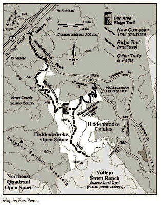
Getting to the Ridge Trail from the communities we live in is an important goal of our 500-mile trail project. In November, we celebrated the opening of a trail that will get you to the Ridge Trail—the Hiddenbrooke Connector Trail in Vallejo. This one-mile trail connects neighborhoods on the Hiddenbrooke Parkway to the 2.5-mile Hiddenbrooke Ridge Trail dedicated in 2001. The inspiring views extend to Mt. Diablo and the Carquinez Strait, as well as to Skyline Wilderness Park and the Napa Solano Ridge Trail in Napa County.

This is the eighth consecutive year of annual Ridge Trail dedications in Solano County, which is a record for all of our counties. The council’s Solano County Committee has lined up at least two more dedications over the next two years, which will add up to a decade of annual dedications by 2010!

Fore!!! more nature in San Francisco...

-
Restore Nature to a San Francisco City Golf Course?


http://www.restoresharppark.org/

Sharp Park Habitat Restoration Proposal Public Hearing April 30, 2009, 1pm San Francisco City Hall (ACTION ITEM)

Finally, Earth Day seems like a good time to remember that public lands issues, even federal ones, don’t just involve areas that are removed from our bigger cities and towns. Areas in our own backyards are important as well for many reasons, not least is that they are often the first introduction that kids get to the outdoors, which can lead to a lifelong fascination with nature. They are no less worthy of protection than our wilderness areas and national parks. One such area is Sharp Park, a golf course located in Pacifica, but owned and operated by the city of San Francisco, located just to the north. The golf course is known habitat for the red-legged frog and the San Francisco garter snake, both federally-listed endangered species. The golf course and its impacts on these species have been the subject of controversy for several years now, and one of San Francisco’s supervisors has come up with a proposal to turn the golf course over to the Golden Gate National Recreation Area so that the National Park Service can restore it, as it is doing on land adjacent to the golf course (alone or jointly with San Francisco). Our friends at the Center for Biological Diversity and Nature in the City are among the leading supporters of the proposal, which has attracted attention from all quarters. The San Francisco Board of Supervisors will be holding a hearing on the proposal next Thursday, April 30.

We encourage people who support habitat restoration efforts to attend if they are able. The hearing will be at: San Francisco City Hall 1 Dr. Carlton B. Goodlett Place 1 p.m.

More information on the issue can be found online.
San Francisco Chronicle
http://www.sfgate.com/cgi-bin/article.cgi?f=/c/a/2009/04/08/BA9716SDVJ.DTL

Center for Biological Diversity

http://salsa.democracyinaction.org/o/2167/t/5243/content.jsp?content_KEY=5628


Hike near threat to Mt. Diablo Park

-
See the Threatened Roddy Ranch, Sand Creek & the unknown "Panhandle" Black Diamond in East SF Bay


Hike Date: May 17th, 2009, from Save Mount Diablo


Antioch is proposing thousands of houses in the valleys stretching east from Black Diamond Mines. Including at Roddy Ranch & at the Higgins Ranch, two beautiful & bucolic areas along Empire Mines Rd, which is closed to vehicle traffic. Join Scott Hein, SMD's resident photographer & Chair of its Land Committee, to hike through the Preserve past the historic Star Mine to see what's at stake. Years ago the Regional Park District acquired a narrow "panhandle" of open space between Roddy Ranch & Higgins Ranch which allows us to see more remote areas, including the sites of two coal mining towns. The moderate 7.25 mile loop includes 670' elev. gain & should take 3-4 hrs, or you can turn back at any time. For a shorter hike, park at the intersection of Mesa Ridge & Empire Mine.

Mines Leader: Scott Hein (925) 671-0401 or scott@heinphoto.com


http://www.savemountdiablo.org/Hike%20Schedule%20Calendar/Spring.htm

Healthy forest v. grape estates...

-
Sonoma County Holds First Hearings on Planning for "Preservation Ranch"--forest conversion to vineyards on a massive scale


http://www.sonoma-county.org/prmd/presranch/presranch.htm


Public is invited to attend the following EIR scoping meetings: Saturday, May 2, 2009, 1:00 PM to 3:00 PM Horicon Elementary School 35555 Annapolis Road, Annapolis.

Friends of the Gualala River website: http://www.gualalariver.org/default.html Contact: Chris Poehlmann, poehlman@mcn.org, 707-886-5182

Sierra Club website: http://www.redwood.sierraclub.org/sonoma/Forest.html Contact : Dan Kerbein, dkerbein@earthlink.net, 707-535-0326

Green Diamond Timber-Humboldt sprawl?

-
More Tract Homes in the North coast forest?


4/28/2009-from the The Northcoast Environmental Center and Humboldt Baykeeper

http://healthyhumboldt.org/

CRITICAL LAND USE HEARING THIS THURSDAY

The Planning Commission must hear from us on April 30th
A massive turn out of our constituents for this hearing will be needed to generate the political support to protect Humboldt's agricultural and timber lands from development.

We're asking our members who:
*Support Alternative A's "Community Forest Acquisition and Management Program" that could protect the McKay Tract and create a Community Forest for Eureka

*Would choose a smaller urban footprint over sprawling residential development on Humboldt's prime agricultural lands

*Would like to prevent subdivision and development on industrial timber land to join us at the Planning Commission this Thursday, April 30th The County is expecting people from all over Humboldt to make a point of being at this Town Hall style meeting, and it will likely be moved from the Supervisors' Chambers to the Eureka High School Gym to ensure that there will be space for everyone. So it really is critical that our constituents come out in force and stand in solidarity for the most ecologically sound and community strengthening land-use policies. Again, the details: WHEN: April 30, 6:00pm WHERE: Supervisors' Chambers (825 5th St) or Eureka High School Gym (1915 J St) WHAT: Supervisors meeting regarding the Land Use portion of the Humboldt County General Plan Update WHO: You!

Please check www.healthyhumboldt.org for talking points. In the meantime, please feel free to call Healthy Humboldt at 682-5292. Hope to see you on the 30th!

Obama Admin. Not Going for New Calif. Dams or Peripheral Canal now

-
California's Water: A Vanishing Resource

Interior secretary backs safeguards - Environmental laws to remain in place amid crisis

http://www3.signonsandiego.com/stories/2009/apr/16/1n16water235128-interior-secretary-backs-safeguard/

By Michael Gardner
April 16, 2009

SACRAMENTO – Interior Secretary Ken Salazar yesterday dismissed pleas for President Barack Obama to suspend environmental protection laws that critics say have made the drought dramatically worse for farms and cities.

Salazar also refused to endorse additional reservoirs or a new north-to-south delivery canal – two contentious issues that have contributed to gridlock over water development.

The interior secretary came to California to announce $260 million in federal stimulus funds for water projects mostly centered in the San Joaquin and Sacramento valleys. The goal is to help the state cope with a punishing dry spell and create jobs in depressed farm communities.

Salazar, a former U.S. senator from Colorado, also joined Gov. Arnold Schwarzenegger on a helicopter tour of the Sacramento-San Joaquin River Delta – the hub of California's water system – which is on the verge of collapse.

Afterward, Salazar pledged to work with state officials to develop a uniform approach to solving California's difficult water issues, particularly how to restore the delta.

Legal actions to protect fish have diverted as much as 40 percent of the water that would normally flow through the delta to agriculture and cities in the San Joaquin Valley and Southern California. As a result, farms are fallow and laborers idle.

That has prompted some Republicans to urge the president to convene a rarely used panel of administration officials – widely dubbed the "God Squad" – that has authority to override the Endangered Species Act and allow water to flow more freely.

"Without question, we have been devastated," Senate Minority Leader Dennis Hollingsworth said in a letter asking for the administration to intervene. Hollingsworth, R-Temecula, represents part of San Diego's North County.

Responding to a question, Salazar yesterday said that setting aside safeguards would just be a "temporary fix."

"That is not a solution here," he said. "The solution we are looking for has to be comprehensive in nature."

Salazar said he sympathizes with farmworkers, hundreds of whom are on a four-day march across the dusty Central Valley to draw attention to their plight. He added that renowned farm-labor activist Cesar Chavez "was a friend of mine."

"I feel in my heart very much for those people who are being affected, the members of the United Farm Workers of America ... I know the kind of suffering that they are currently undergoing," Salazar said. "Our hope is some of the money we have made available today will help."

The $260 million for California will include funding for numerous projects, such as $2.5 million for fish and wildlife habitat programs for 8,100 acres along the Colorado River. The Colorado River project will help California, Nevada and Arizona comply with environmental obligations associated with tapping the river for water and hydropower.

The projects also include improving fish populations along the Sacramento River, creating a large water bank so farmers in desperate straits can buy water, and drilling wells.

Salazar also unveiled a separate, nationwide, $135 million grant program for water recycling and conservation, much of which could be available to California.

Tuesday, April 28, 2009

Hurwitz Settles Fed Suit Over Pacific Lumber Fraud

-
Whistleblower Fraud Trial Against Maxxam Corp. and Charles Hurwitz Ends in Settlement


feds take pennies on the dollar in deal over $250 Million Fraud case

-----------------------------
Hurwitz Slithers Back to Houston, Dodging Accountability Once Again

an alert from the Bay Area Coalition for Headwaters April 28, 2009

The whistleblower fraud trial of Texas-based Maxxam Corp. and its CEO Charles Hurwitz, filed by two California Dept. of Forestry staff reached a settlement agreement today after six days before a jury in federal court in Oakland. The federal government will receive $2.5 million from defendants Maxxam Corp. and Charles Hurwitz; the State of California $500,000., and $1 million in costs and fees were awarded to plaintiffs. The case was brought under the False Claims Act. The settlement agreement is, of course, a pittance compared to the profits reaped from the Headwaters Deal for Maxxam and Hurwitz, and also the two-decade milking of the Pacific Lumber cash cow, as northern California's redwood forests were overlogged, hillsides stripped bare and salmon runs depleted.

Although it became clear outside the courtroom after settlement discussion this morning that a number of jurors were solidly behind the plaintiffs, Judge Claudia Wilken had disallowed evidence that would have shown a clear chain of command from Texas to Scotia, California, where Pacific Lumber operated. Exclusion of that information presented a hurdle in the plaintiff's case to show that indeed, Maxxam and its CEO Charles Hurwitz were responsible for decisions to increase logging rates to unsustainable levels. SEC filings uncovered in December 2008 show that Charles Hurwitz, due to testify next week, had spent $13.9 million on this case at the close of 2008.

Our hats off to the courageous whistle-blower CDF forester Chris Maranto, and to former CDF head Richard Wilson for bringing this lawsuit, first filed in 2006. It was a major accomplishment to bring this case before a jury in federal court, despite Maxxam and Hurwitz's monumental efforts at getting it dismissed. It is also significant that Charles Hurwitz, rarely seen in public, has been seated in court daily with his wife Barbara, only several feet away from activists who have been fighting for the redwood forests for many years. Though there were abundant moments of humor in court, Hurwitz never cracked a smile, mostly looking pale and frowning.

Plaintiff's case showed fraud via manipulation of data in computer models used by Maxxam subsidiary Pacific Lumber in their "Sustained Yield Plan"(SYP) for logging on their redwood forest property in northern California. Submission of the SYP to the state cleared the way for the payment to Maxxam and Hurwitz of nearly half a billion dollars in exchange for less than 7,500 acres of redwood forest in the 1999 Headwaters Forest Agreement. The purchase included $380 million in public funds being paid to Maxxam, in addition to several thousand acres of additional timberland being transferred to Maxxam/Pacific Lumber. Hurwitz and Maxxam could have been liable for damages equal to three times the government's losses in the Deal, had plaintiffs prevailed.

The settlement was disappointing, but it remains significant that it came to court and brought Charlie to Oakland. The testimony has been exciting. Congressman George Miller gave strong testimony last week, and former State Senator Byron Sher was due on the stand this week.

Bay Area Coalition for Headwaters 2530 San Pablo Ave. Berkeley, California 94702 510-548-3113 bach@HeadwatersPreserve.org

Los Angeles tables storm-water fee hike

-
A plan to ask city voters to approve a quadrupling of storm-water pollution cleanup fees is shelved over council concerns that it had been rushed and might not pass.


By David Zahniser

http://www.latimes.com/news/local/la-me-stormwater-fee28-2009apr28,0,1689138.story

April 28, 2009 The plan to ask property owners across Los Angeles to quadruple their storm-water pollution cleanup fees over the next five years has been tabled because of concern that it was prepared in haste and might not pass, city officials said Monday.

To get the additional fees in 2010, the City Council had to decide by this week whether to send out more than 800,000 mail-in ballots -- a process rarely, if ever, used citywide. Council President Eric Garcetti said he feared that the plan, which became public only over the last week, would experience the same fate as Measure B, the solar energy plan defeated in the March 3 election after critics said it had been hurried to the ballot. "It's going to get killed, for now," said Garcetti after discussing the plan at the Los Angeles Current Affairs Forum. Mayor Antonio Villaraigosa's appointees on the Board of Public Works voted last week to move ahead with the mail-in ballot plan, which would have asked property owners to hike their storm-water fees from $23 per year for the average parcel to $99 per year in 2013. Sanitation officials had argued that the money was needed to pay for the cost of maintaining projects being built with the proceeds from Proposition O, a $500-million clean water bond passed by voters in 2004. A council vote in favor of the plan would have allowed ballots to go out in June, and if the measure was approved it would have placed the higher fee on property tax bills in December. Board President Cynthia Ruiz said her agency would now develop a public outreach plan for the fee hikes -- one that highlights successes the Bureau of Sanitation has had so far in removing pollutants from storm water. Ruiz said her agency had been aggressively pushing the fee hikes because it was anxious about the mayor's proposed budget, which calls for a 10% reduction in payroll costs at every department -- a plan that could lead to furloughs and layoffs. The fee hike, if approved, would have provided a $24.6-million per year boost to the sanitation agency's budget. Still, Councilwoman Wendy Greuel said she and her colleagues were troubled by the speed with which the proposal had moved. "A lot of questions couldn't be answered to show that it was ready to go," said Greuel. With ballots being mailed to property owners, the fee hikes would have needed a simple majority vote to pass, not the two-thirds typically required in a regularly scheduled election. Garcetti said that, if possible, he would prefer to use a traditional ballot to win approval of the fee hikes, pointing out that Proposition O easily received two-thirds support in 2004.

Monday, April 27, 2009

New Newhall Land EIR is Out

-
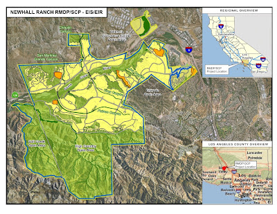
Bankrupt Newhall Land Seeks Approval of EIR from Feds and State Fish and Game for 20,000 homes along the Santa Clara River in North L.A. County


They seek to destroy habitat for the once-extinct San Fernando Valley Spineflower (extinct until it was found at Newhall Ranch, despite the landowner's best efforts to cover it up.) The development plans were approved by L.A. County's supervisors in 2003, but permits must also be given by the state and federal governments as the project sits on prime wetlands and endangered species habitat.

Newhall Land was sold to Lennar Corp. and LandSource soon afterward, and they defaulted on a $1 billion loan last year.

read more:
http://www.cuddyvalley.org/blogs/nimby/?p=331

the group that sued them:
http://scope.org/


the EIR is here:
http://www.dfg.ca.gov/regions/5/newhall/docs/

Public comments are due by June 26, 2009
and all the information about where to write is on the website.

email addresses of the places to send comments are:
U.S. Army Corps of Engineers
Attn: Aaron O. Allen
Aaron.O.Allen@usace.army.mi


California Department of Fish and Game
newhallranch@dfg.ca.gov

-------------------
A Public hearing will be held June 11, 2009 at 6:30 PM at Rancho Pico Middle School, located at 26520 West Valencia Blvd. in the western Santa Clarita area.

Seeking $$ for the Santa Monica Mountains...

-
Will Obama complete the Santa Monica Mountains National Park?


Our Updated Santa Monica Mountains parks purchase map--includes 2008 purchase of 800 acre Corral Canyon and 2005 purchase of the 500+ acres Soka University site.
(Click on map to enlarge)

--------------------------------
excerpted from
http://www.latimes.com/news/nationworld/nation/la-na-land27-2009apr27,0,7967905.story

Making a case for more conservation funds, environmentalists say a down economy is a good time to buy land.

By Richard Simon

April 27, 2009

Reporting from Washington -- Conservationists who for years have struggled to win federal funding for new or expanded parks suddenly are seeing green, even in these lean budgetary times.

President Obama has proposed spending $420 million next year to buy land for national parks, forests and wildlife refuges, and to help states fund parks and recreation projects. That is more than double the amount Congress provided for 2009...

(click on map to enlarge)

For the Santa Monica Mountains National Recreation Area, Reps. Howard L. Berman (D-Valley Village) and Brad Sherman (D-Sherman Oaks) seek $10 million to buy 655 acres in Malibu.

Since the recreation area was created in 1978, the National Park Service has spent $165 million to preserve about 23,000 acres.

But the park has received no money from the Land and Water Conservation Fund since fiscal 2001, even though Bush visited the area in 2003. Some 13,000 acres have been purchased since 2000, with $380 million in state and local funds.

But there remain 25,700 acres to be acquired to complete the land protection plan, officials said...

Sonoma Coast Gem is Almost saved...

-
$$$ Still Needed to Save Gem on Sonoma County Coast


This is part of the massive ranch owned by the Richardson family, who are one of the largest landowners in Sonoma County.


http://www.forestsworkwonders.org/2009/02/pft-close-to-acquiring-renowned-sonoma.html

excerpted from the Summer 2009 edition of the Pacific Forest Trusts's "Forest Life" newsletter


The Pacific Forest Trust is working diligently to complete the purchase of Stewarts Point Ranch, an 871-acre property considered one of the most important unprotected coastal redwood tracts in Sonoma County. PFT would hold and manage the property as an educational center and working model of forest stewardship that sustains wood, water, wildlife and a well-balanced climate.

Among its outstanding features are a full mile of scenic bluffs fronting the Pacific Ocean, a significant stretch of the South Fork of the Gualala River critical for its salmon habitat and 750 acres of well-managed, older Coastal Redwood and Douglas fir forest sustained by its longtime owners, Arch and Jack Richardson, through a family trust....

Stewarts Point Ranch is part of the historic “Rancho German,” one of the last Mexican land grants. It has a rich heritage as part of a constellation of Sonoma County lands that have been owned by various members of the Richardson family since about 1870.

In addition to the commitment of PFT’s own capital funds, we are very grateful to have the support of the Packard Foundation and Community Foundation Sonoma County in our efforts so far. Funding to complete the transaction is being sought from the State Coastal Conservancy, Wildlife Conservation Board and the Sonoma County Open Space and Agricultural Preservation District, along with other foundations and individuals committed to the conservation of these vital Sonoma Coast resources...

Thursday, April 23, 2009

Did Lawsuit Force Feds to Keep Tejon Ranch Documents Secret?

-
Secret Dealings Over Condor's Fate Must Be Unveiled

4/23/2009--After the U.S. Fish and Wildlife Service refused to disclose documents that could be critical to the future of the endangered California condor, last Wednesday the Center for Biological Diversity formally appealed the rebuff of our call to view them under the Freedom of Information Act. The documents concern secret negotiations between the feds and Tejon Ranch Company, which owns a huge swath of California land where condors fly, over the ranch's plans to develop protected condor habitat. We seek not only the information to fill in the gaps in data showing condors' use of Tejon Ranch -- which would obviously be affected by development -- but also to shed light on exactly what promises the Service has made concerning the company's request for a permit to "take" (in this case, harass or harm) condors and a related "habitat conservation plan" involving little (if any) conservation.

"Something stinks here," said Center senior counsel Adam Keats. "The public has a right to these documents that concern Tejon's application for a permit to harm California condors and destroy their habitat."

Check out our press release and learn more about California condors and our campaign to save Tejon Ranch.

http://www.biologicaldiversity.org/news/press_releases/2009/tejon-ranch-04-15-2009.html

http://www.biologicaldiversity.org/campaigns/save_tejon_ranch/condor_controversy_history.html

excerpts:

January 23, 2009 – The Center files its fifth Freedom of Information Act request seeking documents related to Tejon Ranch and the proposed plan.

February 4, 2009 – The Service publishes its Notice of Availability of the Draft plan and environmental impact statement in the Federal Register and announces that the deadline for comments has been extended to May 5, 2009.

April 8, 2009 – Fish and Wildlife denies the Center's Jan. 23 request, disclosing only four miscellaneous documents in addition to those found on the agency website for the draft plan. The Service's denial follows two separate notices of delay that are due, according to the agency, to the voluminous records and complexity of the legal issues regarding the records. Fish and Wildlife Service's denial again cites the protective order, stating that it "prohibits the disclosure of all documents and records created and produced in relation to and for the purposes of developing the recently submitted [plan]…"

State's Water Hogs face a Catch-22 Situation

-
Dropping Fish protections would not add much for growers

excerpted from:
http://www.capitalpress.info/main.asp?SectionID=67&SubSectionID=616&ArticleID=50709&TM=52583.67

4/23/2009--As some lawmakers hold up the Sacramento-San Joaquin Delta's endangered fish as a symbol of the farmer's struggle with environmental rules, others are bypassing the notion to focus on long-term fixes to the state's distribution system.Farm interests, many Central Valley business organizations and their Congressional representatives have called for suspension of Delta irrigation pumping restrictions now protecting the Delta smelt under the federal Endangered Species Act to help ease drought impacts. They also favor improvements to the infrastructure.Others in government, sympathetic to the farmers' plight, say the long-term fixes are the only viable solution to the state's water woes.Two factors likely influence that approach. First, the idea of lifting Endangered Species Act restrictions from the Delta is widely expected to go nowhere in Congress. That's a reality blamed on Democratic lawmakers resisting any challenge to environmental laws. But it combines with another reality: lifting ESA rules from the Delta wouldn't improve water availability by much.

Lester Snow, director of the state's Department of Water Resources, estimates that without ESA rules on Delta water, state irrigation allocations might be reaching 35 percent this year, instead of 30. Federal officials give a similar estimate - the Central Valley Project's 10 percent allocations for south-of-Delta farmers might rise to 15 percent, they say."If the ESA goes away this afternoon, we still have a drought," Snow said last week.

Snow also said he believes that pumping restrictions can't save the endangered Delta smelt - the fish called the most precarious of several dwindling Delta species - because the Delta in its modern form won't sustain its populations. Therefore, a relaxing of some restrictions to help relieve economic hardship, especially on the San Joaquin Valley's hard-hit west side, shouldn't be out of the question, Snow said."I believe you could shut the pumps off forever and not recover the smelt," he said. "And then what have you lost?"Interior Secretary Ken Salazar has dismissed the notion of lifting species protections."That is not the solution here," Salazar said April 15 in Sacramento, after touring the Delta by air with Gov. Arnold Schwarzenegger. "The solution that we're looking at is one that is going to have to be comprehensive in nature that takes into account the huge variations you're seeing in water supply."...

More Tejon Ranch News...

-
Is there yet another endangered species living at Tejon Ranch?

If the Tehachapi slender salamander, which lives north of L.A., becomes a protected species, urban growth could be limited.

http://www.latimes.com/news/local/la-me-salamander28-2009apr28,0,135726.story

By Louis Sahagun
April 28, 2009
Jeremy Nichols says he became smitten by the Tehachapi slender salamander when he ran across an article about it four years ago in a book about North American reptiles and amphibians.

The brick-red and stealthy Batrachoseps stebbinsi clings to existence in two canyons about 13 miles apart and separated by a freeway 60 miles north of Los Angeles. It lives mostly underground and, without lungs, absorbs oxygen through its skin. When threatened, it can coil its body like a snake.

"I'm not a scientist, but I know enough to understand that these little guys are not adept at crossing freeways," Nichols, 29, of Denver, said in an interview Monday.

So Nichols, acting as a private citizen, filed a petition in 2006 requesting that the U.S. Fish and Wildlife Service list the salamander as an endangered species because of ongoing threats to its subterranean haunts. He cited Tejon Ranch Co.'s development plans, mining, livestock grazing and road construction as threats.

The agency agreed on Wednesday to study the matter, declaring in the Federal Register that Nichols' petition presented "substantial scientific or commercial information" to warrant a comprehensive review.

That could see the broad-headed, long-limbed salamander -- first scientifically identified in 1968 by noted herpetologist Robert C. Stebbins -- brought under federal Endangered Species Act protections within a few years.

The announcement does not mean that the Fish and Wildlife Service has decided to list the species, just "that there was enough information presented in the petition for us to take an in-depth look," said Lois Grunwald, a spokeswoman for the agency.

Ilene Anderson, a spokeswoman for the Center for Biological Diversity, a nonprofit conservation organization, praised the move on behalf of a creature already listed as threatened by the state of California.

"If we're going to save California's natural heritage, including this salamander, more land needs to be protected from urban sprawl," she said in a statement.

Barry Zoeller, spokesman for Tejon Ranch, said the company has no plans to develop any area "were the Tehachapi slender salamander is found or may be found."

Unlike many salamanders, the enigmatic species is a terrestrial breeder that lays its eggs in moist soils deep beneath rocky north-facing canyon slopes.

It is unknown how long it lives, and no juveniles have been seen in the wild or reported.

Nichols, a climate program director with Wild Earth Guardians, an environmental group based in Santa Fe, N.M., said he's never seen a living Tehachapi slender salamander.

But he added, "The canyons where it is found are now on my list of places in the West to visit someday."

---------------------------
http://www.biologicaldiversity.org/news/press_releases/2009/tehachapi-slender-salamander-04-22-2009.html

Another Tejon Species, the Tehachapi Slender Salamander,
Headed for Endangered Species Protection

4/22/2009--LOS ANGELES— The U.S. Fish and Wildlife Service today announced that the Tehachapi slender salamander could warrant federal Endangered Species Act protection due to the destruction of its very limited habitat in the Tehachapi mountains and southern Sierras of California. The salamander now lives primarily on Tejon Ranch, the massive, privately owned biodiversity gem north of Los Angeles.

"The Tehachapi slender salamander has taken a beating in the northern part of its range, while its southern range is now threatened by proposed developments on Tejon Ranch," said Ileene Anderson, a Center for Biological Diversity biologist. "This very rare animal needs immediate protection."

The Tehachapi slender salamander is known from only two populations. One in Caliente Canyon in the southern Sierras and one in the Tehachapi Mountains entirely on Tejon Ranch. Development plans on Tejon Ranch threaten five of the known locations of the secretive salamander. The salamander is also threatened by road construction, mining, livestock grazing, and flood-control projects. It has, for example, been eliminated from the Tehachapi Pass area due to highway construction.

"Development of Tejon Ranch poses an immediate threat to the Tehachapi slender salamander and dozens of other species," said Anderson. "If we're going to save California's natural heritage, including this salamander, more land needs to be protected from urban sprawl."

The Tehachapi slender salamander, first scientifically identified in 1968, was petitioned for listing under the Endangered Species Act in 2006. It is an enigmatic species that lives on rock talus and leaf covered slopes on northern exposures from the Kern River Canyon south to the Fort Tejon area – a range of less than 60 miles. Unlike many salamanders, the Tehachapi slender salamander is a terrestrial breeder, and it is believed that it lays its eggs in the moist soils underlying the deep rock talus and leaves that make up its habitat. It is unknown how long the Tehachapi slender salamander lives. Juveniles of the species have never been documented.


Contact: Ileene Anderson, Center for Biological Diversity, (323) 654-5943

Santa Barbara's Environmental Defense Center--Earth Day Report

-
What the Central Coast's Environmental Defense Center Does

http://edcnet.org

We are thankful for the opportunity to represent the public, and for the opportunity to speak for those who cannot speak for themselves. We are thankful for the variety of important issues that we get to tackle. Here is just a sampling of what EDC is working on now:

* Addressing the causes & effects of climate change at local, state & federal levels
* The Mission Creek steelhead restoration and flood control projects
* Preserving open spaces & agriculture on the Gaviota Coast & at Naples
* Enhancing marine reserves in & around the Santa Barbara Channel
* Protecting Ormond Beach in Oxnard
* Recovering steelhead in the Santa Ynez River
* Working to end oil & gas development on & offshore Santa Barbara County
* Developing agricultural discharge regulations
* Reporting on the causes & effects of ocean acidification
* Commenting on the scoping plan for the Bacara Resort & Spa expansion project
* Finding solutions to protect Goleta Beach
* Creating policies to protect agriculture from suburban sprawl

Wednesday, April 22, 2009

-
Tejon Area Newspaper Publishes Tough Criticism of Condor Development/Preservation Plan


excerpted from
http://mountainenterprise.com/atf.php?sid=4761


April 10, 2009
"...Inside the box was the hard copy of a four-volume set of documents that, if printed from the online version at the FWS website, would total 5,200 pages of maps and data—equal to 10 reams of paper. This is the “Tehachapi Uplands Multispecies Habitat Conservation Plan” (HCP).
The window for public comment during this phase of the permitting process closes on May 5....

After 100 hours of effort among three people, we conclude these documents have not been proofread responsibly. They appear to have been prematurely released to the public for comment. As reporters, this is a disappointment. The stakes are high for the developer, for the endangered species and for the people of California....

--DISCREPANCIES BETWEEN MAPS AND TEXT IN HCP
--DISCREPANCIES BETWEEN MAPS AND TEXT IN THE DEIS
--INCONSISTENCIES REGARDING SIZE OF PROPOSED DEVELOPMENT

...The above sampling of notes reflect only a superficial preliminary overview of the sections of these documents specific to the California Condor, neglecting inquiry at this time into 26 other species..."

The window for public comment during this phase of the permitting process closes on May 5.

-----------------------
and from part II, published 4/17/2009:
http://www.mountainenterprise.com/atf.php?sid=4738

Both Tejon Ranch Company and the U.S. Fish and Wildlife Service responded to the April 10 story. That is posted at the link above. The editors of the Mountain Enterprise posted this response to their responses:

"...We appreciate that both Tejon Ranch and the U.S. Fish and Wildlife Service (FWS) shared their replies. We were surprised to see that both go to some effort to dodge the real question raised by The Mountain Enterprise:

It is not the length of the documents that is of concern, it is their sloppiness.
Contradictions between maps and text, maps and maps, text and text and DEIS to HCP are of such frequency and severity that they create a barricade of errors between the reader and meaningful consideration of the important science that should be the focus of such work.
It is a fiction to claim our report was about “complexity.” It is about self-contradiction within the documents themselves which create material obstruction to public comment. The result, we report with disappointment, creates a parody of what both writers here call “the public comment period.”"

---------------------

Meanwhile, a 600 to 800 home proposed housing tract in the same valley as Tejon's resort proposal is out of water...

excerpted from:

http://www.mountainenterprise.com/atf.php?sid=4727

"...In the April 14 interview, Hager (president of the board of the local water district) said, “Our consultants Kennedy/Jenks showed that the Arciero statistics were not accurate last time. If the new development had been built last year, our consultant said the whole [existing] community already here would have been out of water in nine to 12 months because of the drought.”

If built, Arceiro’s Frazier Park Estates would surround Frazier Mountain High School. Water table readings in the area in 2007-08 were shown to have plummeted 53 feet in a year. The first draft EIR for Frazier Park Estates was withdrawn in 2006 after substantial public comments pointed out numerous flaws in the draft EIR, including inadequate proof of a sufficient water supply to support the proposed doubling of the area’s population..."

Tuesday, April 14, 2009

San Mateo County Coast Railroad Right of Way and Depot Tours

-
Half Moon Bay Greenway Tours

Two Nature and History Events Coming Up — April 18 & 19

April 18, 10 am: Tour of Railroad Right-of-Way in Half Moon Bay — free

The Ocean Shore Railroad operated for the first two decades of the 20th Century, bringing people to the then sparsely populated San Mateo coast and giving birth to the towns we know today as Pacifica, Montara, Moss Beach, El Granada and Half Moon Bay.

Although the Railroad is gone today, there is an area in Half Moon Bay called the Railroad Right-of-Way (RRoW) which is still vital to the town of Half Moon Bay. The RRoW runs from Kelly Avenue south to Seymour Street between the western edge of the Arleta Park and Alsace Loraine neighborhoods, and a pristine open space bluff top overlooking the Pacific Ocean. The Coastside Land Trust (formerly HOST, or Half Moon Bay Open Space Trust) worked with a group of coastside residents to raise the funds for the City of Half Moon Bay to purchase the RRoW from private owners in 2004. The Coastside Land Trust is the holder of the conservation easement over the RRoW and is sponsoring the April tour, which is designed to familiarize the local community with the history of the railroad, wildlife and native plants that are abundant in the area.

The tour will start at 10 a.m. across from the original Arleta Depot (which has been a private home for many years) at the corner of Poplar St. and Railroad Ave. in Half Moon Bay. Members of the board of directors of the Coastside Land Trust and Executive Director Jo Chamberlain will welcome participants and discuss the environmental significance of the RRoW easement for the coast. Native plant specialists Avis Boutell and Nancy Frost will speak about the California native plants found in the area. Gary Deghi, a professional biologist, will describe the wildlife that inhabit the area and highlight bird species of interest. Local historian Liz Allison will talk about the railroad's history.

Participants will walk along the Railroad Right-of-Way with our native plant, wildlife and history guides who will tell us more about the richness of the area at each of the successive three "stops": Central Avenue and Railroad Avenues at 10:45 a.m; Miramontes Avenue and Railroad Avenue at 11:15 a.m.; and the bluff edge at 11:45 where we will view two endangered plant species, view ocean-dwelling birds and hear more about the Ocean Shore Railroad history. The event will conclude at 12:30.

April 19, 1 pm: Tour of Railroad Depots — $25 per person, under 18 free

Join us as we retrace the path of the famed Ocean Shore Railroad. Participants will meet at the Vallemar Restaurant (a former depot), 2125 Coast Highway in Pacifica, where we will view two models of the famed railroad and enjoy numerous photographs showing the Railroad and period coastal views. Following an overview of the railroad's history by tour conductors, participants will drive to see one of the remaining railroad cars, which is housed in Pacifica, and several of the remaining depots in Pacifica, El Granada and Half Moon Bay.

Space is limited and pre-registration is suggested by visiting CoastsideLandTrust.org and making a $25 donation.


The Coastside Land Trust is dedicated to the preservation, protection and enhancement of the open space environment including the natural, scenic, recreational, cultural, historical, and agricultural resources of Half Moon Bay and the nearby areas. There will be an opportunity for interested volunteers to sign up to help the Coastside Land Trust with a number of upcoming activities.


Jo Chamberlain
Executive Director
840 Main Street #B2
Half Moon Bay, CA 94019
650-284-5056 office
650-346-3775 mobile
joc@coastsidelandtrust.org

Power Lines through the Sutter Buttes?

-
Proposed 500 Volt Transmission Lines Through

Sutter Buttes and Central Sacramento Valley

Dear Middle Mountain Foundation Supporters,

4/13/2009--Recently, we at the Middle Mountain Foundation learned of a project to construct new electric power transmission lines with proposed routes near and in the Buttes. I made contact with TANC, the company responsible for the project, and they are very willing to reroute the power lines away from the Buttes. What they need are constructive suggestions from concerned citizens about the best alternative routes for the lines.

There are public meetings scheduled for this week that will allow us to get our comments on the record. Tomorrow night's meeting is being held in Williams, at 5:30 at Granzellas Inn (451 6th Street, Williams). For all information regarding this project, including maps for the proposed routes, please visit:

See the Proposed Transmission Lines Route:

http://www.tanc.us/content/blogsection/7/48/

With your positive input and creative suggestions, we can ensure this project has the best outcome for all concerned.

Thank you,
Cory D. Wilkins
Executive Director
Middle Mountain Foundation

Friday, April 10, 2009

-
Todd Ranch adds 738 acres to Knoxville Wildlife Area


4/1/2009---After 15 years, the Land Trust of Napa County has completed efforts to purchase another 738 acres for the Knoxville Wildlife Area north of Lake Berryessa. $3.37 million in Funds to complete the purchase came from the California Wildlife Conservation Board.

http://newspherenapa.com/2009/04/todd-ranch-adds-738-acres-to-knoxville-wildlife-area/

http://www.napalandtrust.org/frameland.html

http://rare-earth-news.blogspot.com/2008/07/total-of-8648-acres-of-california.html

-
Acquisition of two land parcels in southern Sierra Nevada will protect two ecologically rich areas in Tulare County


http://www.landtrustalliance.org/community/Regions/west/success-stories/legacy/

The Wilderness Land Trust just took a major step forward in creating a wilderness legacy in the Southern Sierra Nevada Mountains with the acquisition of two ecologically rich parcels of land.

“We are grateful for the vision and effort that the Wilderness Land Trust has put into the acquisition of these two significant properties”, said Tim Smith, BLM Bakersfield Field Manager. “The initiative that the Wilderness Land Trust has taken to work with willing sellers to conserve these lands will greatly benefit the public in the preservation of wilderness and resource values into the future.”

The land trust acquired two properties; a 200-acre inholding in the Domeland Wilderness and a 2,435-acre property adjacent to the Sacatar Trail Wilderness. An inholding is privately owned land inside the boundary of a national park, national forest, state park, or similar publicly owned, protected area.

Both parcels are in Tulare County east of the Sierra crest and will be passed on to the Bureau of Land Management (BLM), which will manage the areas as wilderness. Both parcels support rich archeological resources, numerous springs, and opportunities for hiking into the rugged backcountry. The Domeland Wilderness inholding is situated along a major tributary to the South Fork Kern River. The parcel is within a quarter-mile from the Pacific Crest Trail and supports lush riparian habitat and Pinyon-Juniper Woodlands that are surrounded by rugged granitic peaks.

The 2,435-acre property adjacent to the Sacatar Trail Wilderness includes expansive wet meadows straddled by Pinyon-Juniper Woodlands and an isolated stand of Joshua Trees that occur at an elevation just over 7,000 feet.

"We are delighted that the Wilderness Land Trust could step in and work with willing sellers to protect these important wilderness properties," said Trust President Reid Haughey from the organization’s home office in Carbondale, Colo. "We have the opportunity to decommission several miles of roads and remove fences and other wilderness intrusions that will restore the lands to their natural state."

The Domeland Wilderness inholding will automatically be incorporated into the surrounding wilderness area. The 2,435-acre ranch adjacent to the Sacatar Trail Wilderness will expand the adjoining wilderness area as per the 1964 Wilderness Act, which says lands adjacent to congressionally designated wilderness areas can be annexed to those wilderness areas through administrative means if the lands are donated to the federal government.

Founded in 1993, the Wilderness Land Trust is a non-profit, publicly supported charity that works to purchase private lands (inholdings) within wilderness. All of the lands acquired by the trust are transferred to public ownership through voluntary mechanisms that respect landowner property rights and values. The trust has protected nearly 30,000 acres in more than 60 different wilderness areas across California, Arizona, Oregon, Washington, Montana and Colorado. To learn more about the work of the Wilderness Land Trust, visit their Website at http://www.wildernesslandtrust.org

-

Assorted Goodies on Calif. WATER POLITICS:


Delta fish get new environmental protections

http://www.biologicaldiversity.org/news/center/articles/2009/san-jose-mercury-news-03-04-2009.html

San José Mercury News, March 4, 2009

The Fish and Game Commission voted unanimously Wednesday to list the longfin smelt as a threatened species under the California Endangered Species Act.

Commissioners also voted to classify the longfin's cousin, the tiny delta smelt, as an endangered species, moves hailed by environmentalists as a victory for the fragile ecosystem and its bellwether species.

-------------------------------

Lawsuit Looming Over Bay-Delta Fish Protection

http://www.biologicaldiversity.org/news/press_releases/2009/smelt-03-24-2009.html

3/24/2009--While the state of California is moving (slowly) toward safeguarding two of the San Francisco Bay-Delta's most imperiled fish, the longfin and delta smelt, the U.S. Fish and Wildlife Service has stalled on responding to petitions for protection -- so this week, the Center for Biological Diversity and the Bay Institute filed a notice of intent to sue. In 2007, the Center and allies petitioned the federal government and California to protect the longfin smelt, but the Bush administration didn't make a decision on protection by its August deadline. Way back in 2006, the Center petitioned to upgrade the delta smelt's federal and state Endangered Species Act status from threatened to endangered -- but 23 months after a decision was due, the feds still haven't responded. Luckily, California has been a bit more proactive, designating both fish as candidates for greater protections. But meanwhile, thanks to degraded conditions in the Bay-Delta caused by water diversions, pollution, and introduced species, both the delta smelt and the Bay-Delta population of the longfin smelt are fading fast. The "smeltdown in the Delta" -- as the extinction trajectory of Bay-Delta smelts is known -- is on fast-forward, but despite court orders to clean up their act, federal and state water agencies are still mismanaging California's largest and most important estuary. Check out all the details in our press release and learn more about the delta smelt and longfin smelt

http://www.biologicaldiversity.org/news/press_releases/2009/smelt-03-24-2009.html

--------------------------------------------

http://www.water.ca.gov/deltainit/maps0309.cfm

bay delta conservation plan EIR EIS page—with maps of peripheral canal routes

------------------------

http://aquafornia.com/archives/7770

http://westchesterparents.org/?p=2128

structure discriminate against families?">Does L.A.’s proposed water rate
structure discriminate against families?

----------------

http://www.norcalwater.org/

fans of Sites reservoir

http://www.norcalwater.org/images/sites_green.jpg

map of it

---------------

http://www.argentco.com/htm/f20041001.885710.htm

10/2004--Third District Appeals Court Finds Counties May Regulate Private Reservoirs
Delta Wetlands Properties v. County of San Joaquin


-

Court Battle is soon over Santa Barbara Coastal Oil Drilling

Paredon Goes to Court on April 21

http://edcnet.org/

from EDC 4/6/2009--For the past three years, the Environmental Defense Center, Carpinteria Valley Association, Citizens for the Carpinteria Bluffs, Get Oil Out! and the Sierra Club Los Padres Chapter, along with hundreds of Carpinteria residents, have participated in the City of Carpinteria's review of the proposed Venoco oil drilling project known as "Paredon."

On February 2, 2009, Venoco, Inc. notified the City of Carpinteria that the company intended to circulate an initiative petition regarding the proposed Paredon oil drilling project. Although it pretends otherwise, Venoco's initiative would completely circumvent the City's normal public planning and environmental review processes, and would deny the community access to critical information. It would discourage informed public dialogue and community engagement, vital and necessary components of any planning process. In addition, the oil company has drafted an initiative that violates the California Constitution and a host of other state laws. The City is charged with upholding the law and preserving the public welfare, and Carpinteria officials acted responsibly when they requested a judicial ruling on the legality and appropriateness of Venoco's oil drilling initiative.

The Carpinteria City Attorney's complaint lists six causes of action against Venoco, including charges that the initiative contains provisions that are unconstitutional and illegal under state law. For example, voter initiatives may only propose legislative, or law-making, acts; administrative acts, such as issuing development permits, may not be proposed by voter initiative. The complaint further describes how the initiative is inconsistent with Carpinteria's General Plan, how the initiative is "unconstitutionally vague, misleading and contains false statements," how it conflicts with the California Environmental Quality Act (CEQA), and how it would "impair essential government functions" of the City of Carpinteria.

None of the City's claims impedes or disparages public involvement or community decision-making; the City is actually working to protect these citizen's rights. The City's case will is currently scheduled to be heard in Superior Court on April 21 (date may be subject to change: stay tuned).

EDC and our clients support the City of Carpinteria in its efforts to preserve the public planning process.

-
Water Agency Threatens Mokelumne River


http://www.friendsoftheriver.org/site/PageNavigator/FOR%20pages/California%20Rivers/FORCalRiversMokelumneRiver

4/2009--Friends of the River and other conservationists have worked for years to improve flows in the Mokelumne River for fish, wildlife, and recreation, as well as to enhance recreational access. A proposed reservoir expansion threatens to drown these recent environmental and recreational gains.

The East Bay Municipal Utility District (EBMUD) is proposing to expand the existing Pardee Reservoir to increase the reliability of drought year water supplies for its service area.

The issue really comes down to fear. The fear of future water shortages is being used as pretext to attack California’s free-flowing rivers. In this case, some at the East Bay Municipal Utilities District (EBMUD) are advancing a plan to enlarge Pardee Reservoir, a move that would drown an additional two miles of the Mokelumne. The threatened river is loved by many for its beauty, for its beginner kayak runs and year-round angling. This would be needless river destruction.

The key word is needless. EBMUD does not need to drown more of the Moke to get the water they need. As a matter of fact, alternatives have already been laid out for the EBMUD Board (some of who support the alternatives, but some still need to be won over).

http://www.foothillconservancy.org/pages/ws_maps.cgi

http://calrivers.blogspot.com/ for the Friends of the Rivers' news blog

Development of Delta island stopped...

-
UPDATE: RENEWED FIGHT AGAINST DELTA DEVELOPMENT IN Contra Costa co.


10/1/2009--Great news! Greenbelt Alliance won its lawsuit to protect farmland in the City of Oakley, a fight that began in 2006. In an important decision announced October 1, Superior Court Judge Barry Baskin ruled against the Contra Costa County town, denying its request to move forward with its plan to build 5,000 houses in an unsafe area on important farmland. In a strong statement, he repealed the environmental impact report for the East Cypress Corridor project, effectively blocking the development and ordered Oakley to address the loss of agricultural land.

"This is a huge victory for the Bay Area and the state, because cities will have to pr

http://www.greenbelt.org/regions/eastbay/camp_oakley.html

http://www.greenbelt.org/resources/press/clippings/clip_2009oct2_CC.html

Oakley must now re-evaluate its environmental impact report for a second time to show how it will offset the loss of 828 acres of farmland in the Hotchkiss Tract.

-------------------------------------------

Greenbelt Alliance Fights Delta Development

http://www.greenbelt.org/resources/newswire/2009aug.html

On July 24, 2009, Greenbelt Alliance pressed ahead with its lawsuit against the City of Oakley to block plans to build more than 5,000 new homes below sea level.

With Eastern Contra Costa County already hard hit by foreclosures and underwater home values, the proposed development on a Delta island is unnecessary and unsafe. If built, air quality would suffer and more than 1,600 acres of agricultural land would be lost.

In 2006, Greenbelt Alliance prevailed in its litigation against Oakley, and the City was ordered to address the loss of farmland. Unfortunately, it later readopted the plan without compensating for the lost agricultural land. Greenbelt Alliance is asking the court to order Oakley once again to set aside its approval of the plan. The hearing is set for Thursday, August 6.

-------------------------


from Greenbelt Alliance April 2009 newsletter--On March 10, Oakley approved the sprawling 3,585-acre East Cypress Corridor Project along the delta. Much of this unwise and remote development sits five feet below sea level on farmland. Climate change and predicted sea level rise of nearly five feet, as reported in the San Francisco Chronicle, make this a foolhardy plan that poses a grave risk to the lives and property of its future residents.

Greenbelt Alliance sued over the project in 2006, winning a requirement for the City to mitigate for lost farmland and poorer air quality. The lawsuit forced the City to redo its environmental analysis but unfortunately, the requirements were unheeded. This senseless development should not go forward.

Read the full story here: http://www.greenbelt.org/resources/newswire/2009april.html#subheading3

LA meetuphikes.org

E-Mail the editor:

rexfrankel at yahoo.com

Blog Archive

Quick-Search of Subjects on the Site